
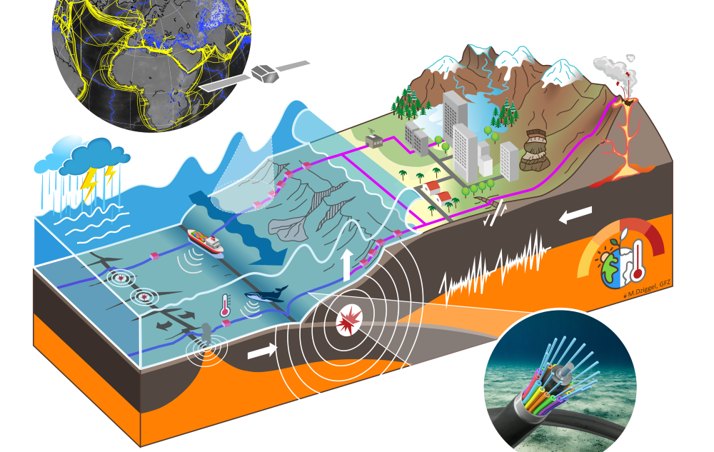
Subsea cables providing a worldwide network of telecommunications could provide the unique potential for scientific use if the fibre-optic cables themselves are used as or equipped with sensors.
70% of our planet is covered by oceans. Compared to the continents, little scientific data can be obtained there, since the ocean floor in particular is difficult to access and therefore insufficiently equipped with measuring stations.

Researchers at the GFZ Helmholtz Centre for Geosciences in Potsdam and the GEOMAR Helmholtz Centre for Ocean Research Kiel are now setting up the research infrastructure SAFAtor (SMART Cables And Fiber-optic Sensing Amphibious Demonstrator), that can be used to monitor the world’s oceans.
Charlotte Krawczyk is the director of the GFZ Department of Geophysics, heads the Section “Geophysical Imaging”, and was instrumental in initiating and advancing the project. She explained:
“There is a huge gap in our observational data, which makes it difficult for us to better understand the effects of climate change on the oceans or the causes of geological hazards like earthquakes, tsunamis or volcano eruptions. We want to close this gap with SAFAtor.”
Over the next five years, the project partners GFZ and GEOMAR want to equip an undersea telecommunications cable with special sensor technology. Around 40 sensor stations will be attached to the cable before it is laid, at a distance of about 20 to 30 kilometres, preferably at the repeater stations. These will continuously supply real-time data on temperature, pressure and ground movement. It must be demonstrated that telecommunications traffic is not disrupted. Fibre-optic cables equipped with intelligent sensor technology are also known as SMART (Science Monitoring and Reliable Telecommunications).
“Telecommunications cables run across the oceans and have to be replaced every 25 years. If we use SMART cables for this, we will be able to achieve simple and comparatively inexpensive sensor coverage of the ocean floor and coastal areas,” added Fabrice Cotton, who is coordinating the entire project as topic spokesperson on geological hazards for the Helmholtz Association.
“The design of the project was a great team effort involving researchers from different disciplines and different age. The European and international integration of this project was taken into account from the outset, and the project is supported by about twenty international organisations,.” He also heads the European GeoINQUIRE project, which has initiated the first developments for disseminating this novel data to the scientific community.
The exact route of the SAFAtor cable has not yet been determined. Possible regions worldwide are currently being explored, including the Mediterranean, the Arctic and off New Zealand. The SAFAtor cable can then serve as a blueprint for future projects, thus advancing international initiatives that want to establish this measurement system on other cables by providing practical and scientific experience.
Laura Wallace from GEOMAR said:
“Real-time monitoring of processes on Earth is the key to protecting society from natural hazards and the effects of climate change. With the help of SAFAtor, we can provide high-resolution data not only for earthquake and tsunami studies, but also for oceanography and climate science, with an infrastructure that has a minimal ecological footprint.”

Leave a Reply