
Published in Orcadian Papers (1905) by William MacKay F.E.I.S.
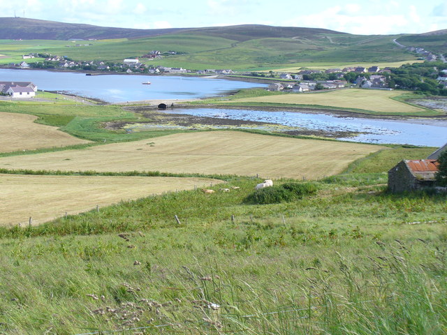
We set out from Stromness and proceeding on our way we are bound to observe that, though passing along an almost level road, we are at no time ten minutes walk from salt water. So nearly, indeed, is the West Mainland bisected here, that a canal of about two miles long, cut from the Oyce of Firth to the Loch of Stenness, would form a water connection between Kirkwall Bay and Cairston Roads.
When a stranger journeying from Stromness to Kirkwall crosses the water-shed at the dykes of Binscarth, he is astonished to find himself so soon again in close proximity to the sea, though only half way to Kirkwall. But more of this again. As we are not on an archaeological expedition we give only passing heed to those works of man, ” hoary beyond tradition’s breath,” the Standing Stones and Maeshowe, which are to be seen on our left, but we rather concentrate our attention on, and give some consideration to, the work of a mightier and more aged hand as seen in the moraines and glacial drift which catch the eye all along our route, beginning with the knoll at Netherbigging, filling the whole district between Hobbister and Finstown with hummocks, and culminating in the twin hillocks between, and partly through one of, which the public road passes on the opposite side of the valley from Binscarth house.
As the result of our cogitations on the why and wherefore of these rounded knolls that here dot the landscape, we arrive at the conclusion that they are the work of glaciers which swept with slow and silent yet irresistible force across the Orphir and Killilang Hills, and which during the latter part of the ice age deposited here those heaps of debris from the adjacent eastern hills.
We do not fail to notice also that in the valley of Binscarth they are confined to the Finstown side of the valley , and that the whole of the opposite side has been brushed bare of excrescences as by the besom of a giant thus proving that the direction of the ice flow has been from south or rather south-east to north-west.
Now let us wend our way down through the village and out the north road to the bridge. Taking our stand there and directing our attention to the sides of the glen through which we have passed, we are struck with the terraced appearance of the hills on both sides. It is worthy of notice, too, that each successive terrace on the one side has a corresponding terrace on the other side of the valley. Further it is remarkable that the dip of the strata on the north side is exactly the reverse of that of those on the south; so that one is given the impression that the edges of the strata on each side of the glen are the abrupt terminations so at one time, continuous strata which the formed a great anticlinal curve, or in plain words that a hill once reared its head where now stretches the peaceful valley of Binscarth. And I am inclined to think this is no mere passing impression but really the only explanation of the facts of the case. That one of the “everlasting hills” has been swept bodily away from, and a deep depression left in, any place looks a bold assertion to make, but let us see what can further be said in confirmation of the theory.
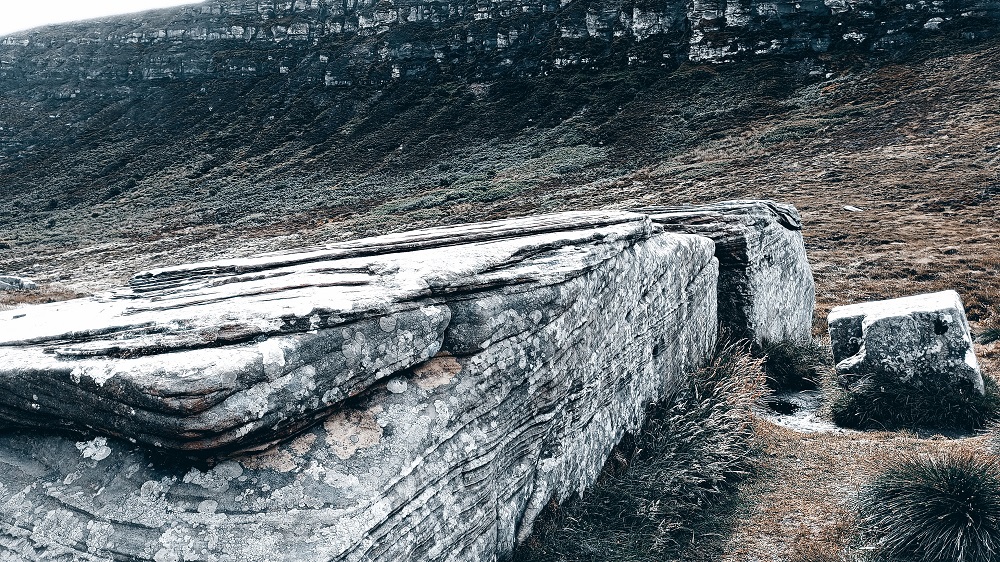
We shall now walk round the shores of the Oyce itself. Everywhere there are traces of volcanic action as best seen in the trap dyke at the hillock near the bridge, and again on the north-west side near the banks of Binnaquoy. Perhaps not anywhere else in the county can the ebullition of the trap and its overflow be better seen than just below this hillock. The molten diabase has here spread over the sandstone and metamorphosed the immediately subjacent stratum, so that the latter is twisted and foliated into such shapes as to remind one of half opened books with the leaves crumpled.

The trap itself is globular, and resembles bitumen. Our survey of the shores will convince us that the space now occupied by the Oyce has at one time been the scene of volcanic action. Now what I wish to bring out is that this ebullition has so weakened the base and shaken the mass of the superincumbent strata that the entire bulk has been crushed on before the Herculean push of the advancing ice river: and that ever as the great glacier received fresh supplies and slowly but surely proceeded it still further eroded the weakened strata so that the bed of the Oyce was hollowed out.
The Oyce has not always been what it now is, – an arm of the sea at high water and a stretch of mud and sand with low water. Beneath a few feet of surface sand and mud is a considerable depth of peat, under which there is marl to an unknown depth. The farmers in the neighbourhood were used to dig this marl and therewith manure their fields. Some twenty years ago, when thus engaged, a farmer dug up the antlers of a stag and the bones apparently of the same animal in situ. A fresh water tarn then must have existed here which, in the course of time, after the retreat of the mer de glace, has been filled up by the creatures whose remains form the marl; then water plants have grown thereon and decayed forming the layers of peat; and lastly the alluvium brought down by the burns has been deposited on the top of the peat. The fact of its now being at sea level is of course accounted for by the general subsidence which took place when the British Isles were separated from the continent of Europe.
More next week on The Oyce of Firth


Leave a Reply