
By Bernie Bell
There are a couple of interesting Tings on Orkney.
Some, such as the one at Tingwall, started as brochs, then became Tings.
And that are Tings? Viking parliaments, that’s what, and, as someone who is all for folk getting a chance to state their case, disputes being settled peaceably, and democracy (however flawed that may be), I have a liking for Tings.
And this brings me to our walk at Dingieshowe ( ting – ding). You park in the little carpark, with its conveniently placed toilet block, then you follow the boardwalk over the dunes, behind the toilet block, to the beach. If you now turn right, and walk along, you’ll find yourself at the Dingieshowe Ting.

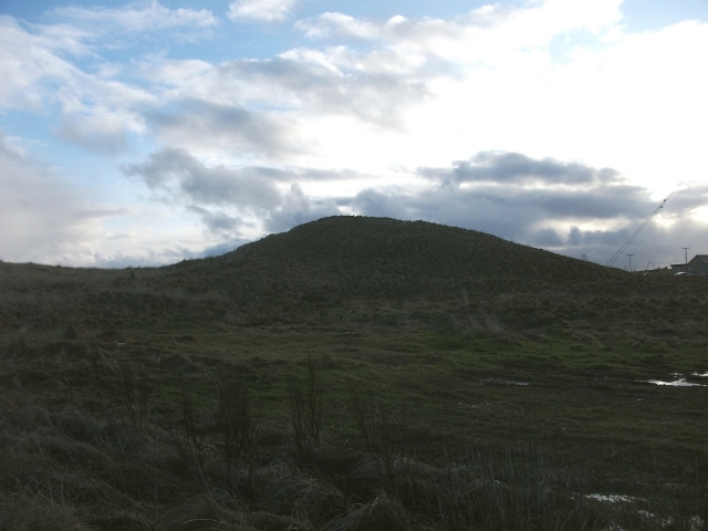
This was also a broch, which became a Ting. You can actually walk about on it, considerately, and imagine the Broch builders

……and the Vikings. I’m not sure how peaceable their parliaments were, as they did have a terrible tendency to lose their tempers, go berserk, burn each other’s houses down and hack each other to bits, but….the idea was there. They did meet, to discuss and decide.
Back on the beach, just along further to the right, in the bank at the top of the beach, there’s what looks like it could be a midden heap, possibly associated with the broch? It contains limpets and cockles, and could be just an old beach level, but it looks like it could possibly be midden.

Then. If you retrace your steps, and walk along the beach to your left, it’s a lovely walk, on a fine day, with views over to Copinsay.

At the end of the beach, it used to be possible to follow the path right to the end, then up some steps onto the top of the cliff, and have a long walk which would bring you back round to the carpark. The first part of this section of the path has been worn away by coastal erosion – the bane of Orkney. More agile folk could clamber over the stones, to pick up on the wooden steps to the continuation of the path, going up the cliff.

We did that walk once, some years ago, and a grand walk it was. If you do cross the stones here to reach the steps, if you look to your left as you do so, you’ll see what I think must be another midden heap. The whole bank is full of limpets, cockles, winkles – could still be an old beach level – but….it also has fish bones dotted through it, which indicates midden, to me.

There is a definite ‘hump’ in the land here, which could all be midden – a midden mound.

But – where is the settlement which produced this midden mound?
As we walked back along the beach, I looked hard, but couldn’t see anything that indicated anywhere that folk may have lived. It could, of course, have been obliterated by on-going farming practices in the time since the midden heap was produced, or, due to the coastal erosion, it could have been swallowed by the sea. If it was a Neolithic settlement, it’s possible that the sea-level was lower, and the settlement was in an area which is now under water. This is an interesting midden mound – associated with??
We then walked back along the beach to the carpark. It’s also possible to walk back through the dunes, for a change of scenery – a bit heavy-going for me!
Then to the Old Library café in Kirkwall for lunch – very good indeed!
And, if you’re interested in midden mounds, have a look at this……….

Leave a Reply