
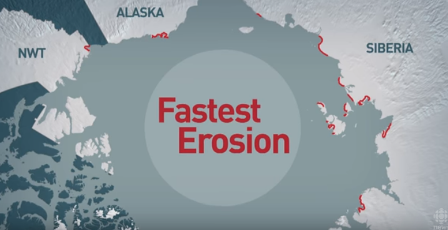
An international team of researchers led by the University of Edinburgh flew drone-mounted cameras over a section of permafrost coastline on Herschel Island, also known as Qikiqtaruk, off the Yukon coast in the Canadian Arctic.
The team mapped the area seven times over 40 days in the summer of 2017.
Their results, from image-based computer models, showed that the coast had retreated by 14.5 metres during the period, sometimes more than a metre a day.
Comparison with surveys dating from 1952 until 2011 showed that the rate of erosion in 2017 was more than six times the long-term average for the area.
Dr Isla Myers-Smith, School of GeoSciences, University of Edinburgh said:
” Big chunks of soil and ground break off the coastline every day, then fall into the waves and get eaten away.”
Coastal erosion in the Canadian Arctic is changing not just the landscape but is threatening the very existence of communities.
Coastal erosion due to ice melt is creating problems across the north of Canada.
The study, led by Edinburgh University was a collaboration with the University of Exeter, Alfred Wegener Institute, Germany, the GFZ German Research Centre for Geosciences, the Vrije Universiteit Amsterdam and Dartmouth College.
It was published in The Cryosphere. The Study was supported by the UK Natural Environment Research Council, the National Geographic Society, and Horizon 2020.


Leave a Reply