
Because talking millions of miles can be inconvenient, especially when it comes to the outer Solar System, we frequently use the Earth’s mean distance from the Sun, 93 million miles, as the Astronomical Unit. By definition, the radius of the Earth’s orbit is 1 AU, and Mars’s orbit ranges between 1.38 and 1.67 AU. Mars can be seen at any time of night but is brightest and closest to us when due south at midnight, when it is at opposition to the Earth. It can then be seen as a disc, even in small telescopes, but is so small as a planet that fairly large telescopes are needed to show markings. At its closest Mars comes to 35 million miles from Earth. What generates close oppositions, such as those of 1956, 1971 and 1986, is that the orbit of Mars around the Sun is markedly elliptical – so enabling Kepler to discover the laws of planetary motion by his study of Mars. So when Mars is close to Earth, it is also at its closest to the Sun (at perihelion), and in 1956 and 1971, Mars was then covered with dust storms. When that happens again, there may be very little to see.

Generally Mars appears to move from west to east, relative to the stars beyond. But as Earth overtakes Mars in its orbit, before passing it on the inside, Mars seems to come to a halt (the stationary point) and then move backwards in a loop with opposition at the mid-point. All the outer planets do the same, and explaining that was one of the big problems with the Ptolemaic idea that Earth was at the centre of the system.
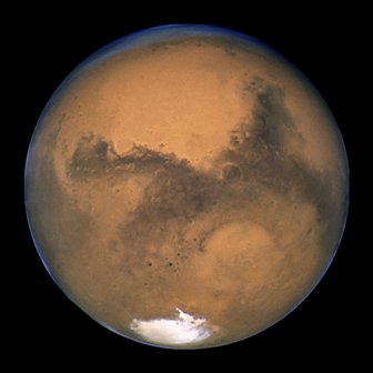
Mars has only half the diameter of the Earth, but because it has no oceans, its surface area is actually greater than the Earth’s land surface. Gravitationally Mars is ‘lumpy’ and appears not to have a fully formed core, which may explain why it no longer has a significant magnetic field though evidently it had one in the past. Surface gravity is about one-thord of Earth’s, about twice that of the Moon.
The first feature on Mars to be observed was the V-shaped Syrtis Major, seen by Huygens in 1659 and by Cassini and Hooke in 1666. ‘Syrtis’ in Latin means ‘quicksand’ and the Syrtes (plural) are the quicksands of Barbary, 250 miles apart in North Africa. In “A Space-Traveller’s Guide to Mars” (Gollancz, 1957), Dr. I.M. Levitt unromantically translated it as ‘the Great Bog’, which would require the presence of water. When the actress playing Deanna Troi in Star Trek: Next Generation adopted ‘Marina Sirtis’ as her stage name, she may not have realised that it could be translated as ‘saltwater marsh’ or ‘coastal swamp’, although we might be more environmentally positive and say ‘tidal wetland’. But estuary quicksands do have more danger and romance about them, like those of the Solway Firth (featured in Sir Walter Scott’s “Redgauntlet”) or the Strand between Colonsay and Oronsay in the Inner Hebrides.
For much of the 20th century no view of Mars was complete without canals and ice-cap. That was a favourite view for artists of the time, particularly Chesley Bonestell in “The Conquest of Space” and later in “The Exploration of Mars” (1956). This was the Mars envisaged by Percival Lowell, a dying world with a huge irrigation programme to keep the last ‘oases’ viable. The canals of Mars were first reported by Schiaparelli, who called them canali, channels, and remained guarded about whether they might be artificial. At the close opposition of 1893, Schiaparelli wrote,
“All the vast extent of the continents is furrowed upon every side by a network of numerous lines or fine stripes of a more or less pronounced dark colour whose aspect is very variable. They traverse the planet for long distances in regular lines, which do not at all resemble the winding courses of our streams. Some of the shorter ones do not reach 500 kilometres, others extend for many thousands, occupying a quarter or sometimes even a third of a circumference of the planet. Some of these are very easy to see, especially the one… designated by the name of Nilosyrtis. Others in turn are extremely difficult, and resemble the finest thread of spider’s web drawn across the disk. They are also subject to great variations in their breadth, which may reach 200 or even 300 kilometres for the Nilosyrtis, whilst some are scarcely 30 kilometres broad… These lines are the famous canals of Mars.” (Schiaparelli in Natura et Arte, February 15th 1893, translated by William H. Pickering and quoted in Willy Ley, “Watchers of the Skies”, Sidgwick & Jackson, 1963.)
Nilosyrtis was the most prominent canal, extending north from Syrtis Major, though the ‘official’ map adopted by the International Astronomical Union in 1958 shows it as detached. Unfortunately, Nilosyrtis as drawn does not exist. It’s faintly sketched in the maps by Patrick Moore and Charles A. Cross based on Mariner 9 imagery, (“Mars, the first authentic guide to another world”, Mitchell Beazley, 1973), but in the US Geological Survey ‘Topographic Map of Mars”, 1976, it’s been broken into two detached tablelands, renamed Nilosyrtis and Protonilus Mensae.
The picture of a civilisation fighting to hold off planet-wide drought by transporting water from the polar caps was enthusiastically developed by Percival Lowell, who also started the search which led to the discovery of Pluto. Knowing that the waterways alone wouldn’t be visible from Earth, Lowell argued that we were seeing the irrigated vegetation which flanked them, and maintained that they darkened and changed colour with the seasons. Dry channels wouldn’t be visible even from orbit, let alone from Earth (see notes on the Great Wall of China in ‘The Moon’).
“…in the Martian mind there would be one question perpetually paramount to all the local labour, women’s suffrage, and Eastern problems put together – the water question. How to procure water enough to support life would be the great communal problem of the day.” (Percival Lowell, “Mars”, 1895).
Vehemently though Lowell denied it, the canals were optical illusions, generated by the propensity of the human mind to link up details on the very edge of visibility. There’s something about Mars which particularly prompts it – I’ve experienced it myself when watching a speeded-up film of Mars’s rotation. Twice in rapid succession, a network of fine lines flashed into view near the rim of the disc. One prompt may be that there actually is a linear feature on Mars, the Great Rift, Valles Marineris, which corresponds to a minor part of Lowell’s canal system. Lowell himself was particularly subject to the effect, because he also drew canals on Venus and the moons of Jupiter. He may even have been psychologically conditioned to it: the fortunes of the Lowell family and the town in Massachusetts which bears their name were based on textile mills fed by a network of canals which gave it the name of ‘the Venice of America’ (Don Lago, ‘The Canals of Lowell’, Griffith Observer, August 1985).
For my “New Worlds for Old” (1979), Ed Buckley produced two matched paintings, ‘Mars in fiction and reality’, which contrasted Ray Bradbury’s Mars of crystal cities and canals with a Viking-type view of the surface as we now know it. But because Ed loves to put mysteries into his paintings, something in the middle distance is reflecting the sunlight – possibly a Lander, or possibly ‘a teaspoon in the Martian dust’, as the late John Macvey poetically put it. In the canal painting, the talking point is the rings in the water, apparently due to Martian trout. The twinned paintings also appeared in “The Directory of Possibilities”, edited by Colin Wilson and John Grant (Webb & Bower, 1981), and the canal one turned up unexpectedly, and uncredited, in the BBC’s live coverage of the Mars Pathfinder landing. (When Pathfinder returned the first pictures of the Martian surface for twenty years, everyone wondered what changes there might have been on the planet. The first picture had to be suppressed because it showed an Irish theme pub, an abandoned supermarket trolley and a Big Issue seller.)


Back when it was thought Mars could have intelligent life, the atmosphere was thought to be about as thick as Earth’s on the summit of Mt. Everest. Actually, the Martian air has only 1% of the density of ours, and it gets thinner during dust storms which absorb the carbon dioxide. In 2004 the Spirit lander was nearly lost because its airbags were released by a barometric sensor, and the Martian atmosphere was a lot thinner than expected due to a recent dust storm. Shortly before that, the British Beagle 2’s airbags were to be activated by a simple timer, but in the thinner air, it would have fallen faster than expected and landed hard, which may explain why only three of its five panels opens and it couldn’t generate solar power.
Mars’s gravity is too low to hold free oxygen, but it does form in summer over the north polar cap, as water vapour is disassociated by solar ultraviolet radiation. It even briefly forms an ozone layer which gives some protection to the cap and surrounding terrain, while it lasts. That would certainly encourage oxidation: it used to be thought (and may still be true) that the large amount of oxidised iron in the Martian crust, giving the planet its red colour, dates from a time when Mars formed a global ozone layer at ground level. (Willy Ley, “Satellites, Rockets and Outer Space”, Signet, 1958.) Due to the lower surface gravity, the density of the Martian atmosphere falls off more slowly with height than Earth’s does, so there’s a ‘crossover point’ above which Mars’s air is denser than Earth’s. In “The Green and Red Planet” (Sidgwick & Jackson, 1954), Hubertus Strughold calculated that pressure at the Martian surface was equivalent to eleven miles above Earth. The crossover point would be about fifteen miles up, on Mars. Having learned from Mariner 4 in 1965 that the Martian air pressure is nearer to 20 miles up on Earth, I’ve wondered even since where that put the crossover point, but I didn’t find out till 2012 when Martin Shelley (ex-BNSC) gave us “Expedition Mars” by Martin J.L. Turner (Springer, 2004) as a belated wedding present. The true crossover is at 122 km (76 miles) above Mars, so all Earth-atmosphere entries occur at higher pressures than over Mars at any height.
The idea that Mars had human or near-human inhabitants lasted into the 1950s and George Adamski’s book about meeting a flying saucer occupant from Venus was followed by a British take-off called “Flying Saucer from Mars” (Muller, 1954), by ‘Cedric Allingham’. Allingham allegedly met his Martian in Scotland and took a number of photographs of a saucer, similar in design to Adamski’s but not identical, and of the Martian, who somewhat surprisingly was wearing braces. There was no telepathic contact. Nor has there been any contact with ‘Cedric Allingham’, who cannot be traced. In his book “Science and Fiction” (Faber, 1957), Patrick Moore claimed to have met Allingham, whom he described as sincere, and in his book Allingham spoke highly of Patrick Moore’s “Guide to the Moon” (first edition 1953), and his account of Mars read like a precursor to Patrick’s “Guide to Mars” (1956). There has been considerable speculation within the Fortean Society and elsewhere that Patrick Moore may have been the perpetrator of the hoax, and argument continues as to whether the two photographs of ‘Allingham’, on the jacket and in the frontispiece, are actually the young Patrick Moore in disguise. In the frontispiece Allingham is posed with a telescope which a friend of mine claims to have seen in Selsey, where Patrick Moore lived. It has to be stressed that Sir Patrick strenuously denied any involvement in the hoax, but it should be noted that in “Science and Fiction” he treated all accounts of meetings with UFO occupants as fictitious.
Part of Nilosyrtis does correspond to the huge rift valley of Valles Marineris, which would stretch right across North America if it was on Earth, with San Francisco and Los Angeles on its south and north rims on the west coast. There’s now evidence that the early history of Mars was more like the Earth’s than anyone since Percival Lowell has thought. One of the major achievements of Mars Global Surveyor was to detect parallel magnetic banding south of the Great Rift, Valles Marineris, confirming the long-standing impression that it was an embryonic ocean – that Mars had initiated plate tectonics, though the process didn’t continue. Analysis by An Yin, UCLA professor of Earth and Space Sciences, found movement between the North and South Marineris plates of 93 miles, roughly half that of the San Andreas fault in California. (Jenny Winder, ‘Scientists Find Clues of Plate Tectonics on Mars’, Universe Today, August 17th 2012).
Next Week: Mars Part 2 – Mars and its Weather
You might also like: The Sky Above You – July 2021
To find the other Beginners Astronomy articles use the search button.

Leave a Reply