
From the International Space Station, GEDI, a NASA space laser, scanned the world’s rainforests. The data being provided can for first time ever provide scientists with information about the rainforests that otherwise we would not have.

Christopher Doughty, professor in NAU’s School of Informatics, Computing, and Cyber Systems believes this research is crucial—and long overdue—in finding out more about the tropical ecosystems.
He explained:
“Most of the world’s species live in tropical forests and most of those make use of the canopy, and yet, we know so little.
“Rainforest structure matters because it controls how animals access resources and escape predators, and these findings will help us understand tropical forest animal’s susceptibility to climate change.”
GEDI, is the Global Ecosystem Dynamics Investigation. GEDI was deployed to the International Space Station (ISS) in 2018 for a two-year mission, and then extended until January 2023.
In 2024, GEDI will return to its original location and resume operations on the station. The mission is now expected to “continue through the life of the space station,’ which is set to be retired in 2031.”
Data acquired using the instrument’s three lasers are used to construct detailed three-dimensional (3D) maps of forest canopy height and the distribution of branches and leaves. By accurately measuring forests in 3D, GEDI data play an important role in understanding the amounts of biomass and carbon forests store and how much they lose when disturbed – vital information for understanding Earth’s carbon cycle and how it is changing. GEDI data also can be used to study plant and animal habitats and biodiversity, and how these change over time. GEDI Earthdata
In March 2023 NASA issued the following statement:
“The International Space Station offers a unique hosting opportunity for Earth science payloads where NASA can test new instrument approaches that can make major contributions to understanding the changing planet.
“NASA’s Global Ecosystem Dynamics Investigation (GEDI) aboard the space station is one of multiple instruments from the agency and others providing critical information about the Earth system and the effects of climate change.
“Demand is high for external attachment points on the station, and GEDI is scheduled to be temporarily replaced by a Department of Defense payload after more than four years of operations. However, the agency is planning to keep the instrument in space and reinstall it to continue through the life of the space station.
“The proposed solution calls for temporarily moving GEDI to an alternate location, where it will remain offline for about 18 months while a DOD technology payload completes its mission. In 2024, GEDI will return to its original location and resume operations on the station.”
Researcher Hao Tang, professor in the Department of Geography at the National University of Singapore (NUS) said:
“A key difference between GEDI and many other satellites is its measurement of three-dimensional canopy structure. Conventional satellites, while providing valuable data on land cover and canopy greenness, often lack the detailed vertical information offered by GEDI. This vertical information is crucial for understanding ecosystem dynamics, carbon storage and biodiversity that cannot be easily seen from typical satellite images.”
Depending on the amount of energy returned to the satellite, GEDI can provide a detailed 3D map that shows where the leaves and branches are in a forest and how they change over time. This will help researchers understand the amounts of biomass and carbon forests store and how much they lose when disturbed—vital information for understanding Earth’s carbon cycle and how it is changing.
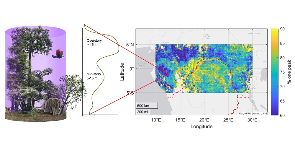
The researchers analysed GEDI data across all tropical forests and found that the structure was simpler and more exposed to sunlight than previously thought.
Data also revealed that most tropical forests (80% of the Amazon and 70% of Southeast Asia and the Congo Basin) have a peak in the number of leaves at 15 meters instead of at the canopy top, debunking the fullest-at-the-top theory of early researchers. While forests vary, a key finding that seemed to remain constant in every scenario was that deviation from more ideal conditions (like lower fertility or higher temperatures) leads to shorter, less stratified forests with lower biomass.
Professor Doughty added:
“It was really surprising to see the dominance of this structure type because it differs from what we had learned in the classic textbooks on the topic.
“These finding will not only help us understand how the millions of species that live in a rainforest canopy might acclimate to changing temperatures, but also how much carbon these forests hold and how good they are at fighting climate change.”
The paper, Tropical forests are mainly unstratified especially in Amazonia and regions with lower fertility or higher temperatures, was published in Environmental Research Ecology


Leave a Reply