
Lost Continents hidden beneath the sea have intrigued scientists and inspired writers for generations. Myths and legends abound around whole communities submerged during a calamitous event.
But there are very real Lost Continents which scientists are discovering more about : the latest findings surround the area known as Argoland.

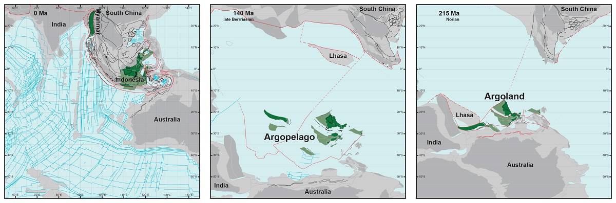
Geologists have long known that around 155 million years ago, a 5000 km long piece of continent broke off western Australia and drifted away. They can see that by the ‘void’ it left behind: a basin hidden deep below the ocean known as the Argo Abyssal Plain. The underwater feature also lends its name to the newly formed continent: Argoland.
The structure of the seafloor shows that this continent must have drifted off to the northwest, and must have ended up where the islands of Southeast Asia are located today. But surprisingly, there is no large continent hidden beneath those islands, only the remnants of small continental fragments that are also surrounded by much older oceanic basins.
So what happened to Argoland?
Geologists at Utrecht University have now managed to reconstruct the history of the lost continent. As it turns out, Argoland is in fragments, but is still there. “Otherwise, we would have been faced with a major scientific problem.”
Geologists differentiate the earth’s crust into the heavier oceanic crust and lighter continental crust. These lighter continents may be partially hidden below sea level.
Utrecht University geologist Douwe van Hinsbergen explained:
“If continents can dive into the mantle and disappear entirely, without leaving a geological trace at the earth’s surface, then we wouldn’t have much of an idea of what the earth could have looked in the geological past. It would be almost impossible to create reliable reconstructions of former supercontinents and the earth’s geography in foregone eras.
“Those reconstructions are vital for our understanding of processes like the evolution of biodiversity and climate, or for finding raw materials. And at a more fundamental level: for understanding how mountains are formed or for working out the driving forces behind plate tectonics; two phenomena that are closely related.”
A piece of continental crust the size of Greenland once separated from North Africa and plunged into the earth’s mantle under Southern Europe – Greater Adria
Like Argoland, Greater Adria, also consisted of different fragments separated by narrow ocean basins, which eventually became part of a single tectonic plate. At some point in the past, Greater Adria plunged into the earth’s mantle, but the top layer stayed behind and was folded to form the mountains of Southern Europe. Argoland, however, left no such trace in the form of folded rock strata.
The scientists spent 7 years trying to find out what happened.
“The situation in Southeast Asia is very different from places like Africa and South America, where a continent broke neatly into two pieces. Argoland splintered into many different shards. That obstructed our view of the continent’s journey,” said Eldert Advokaat.
The shards formed a collage: Argoland is hidden beneath the green jungles of large parts of Indonesia and Myanmar. The splintering of Argoland started around 300 million years ago.
Finding Argoland: reconstructing a microcontinental archipelago from the SE Asian accretionary orogen, is published in Gondwana Research


Leave a Reply