
The Kirkwall schoolmaster who became one of the world’s great mapmakers is to be honoured by the unveiling of a plaque on the Kirkwall waterfront. Murdoch Mackenzie’s 1750 chart of Orkney led to a revolution in mapmaking and was the standard work for navigators until the modern admiralty chart.
The great cartographer: Murdoch Mackenzie

Born in Kirkwall in 1712, Mackenzie studied at Edinburgh University, where he was taught mathematics by one of the great mathematicians of the age, Colin Maclaurin, a friend of Sir Isaac Newton and an expert in surveying. After Edinburgh, Mackenzie returned to his native isles to become the sole teacher at the Grammar School in Kirkwall.
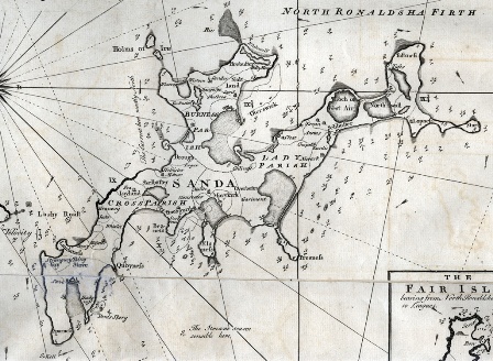
His interest in cartography stemmed from heavy losses in shipping in Orkney waters, particularly on North Ronaldsay and Sanday as ships attempted to navigate the channel between North Ronaldsay and Fair Isle. The catastrophic wreck in 1740 of the Swedish East Indiaman Svecia on North Ronaldsay’s Reefdyke, with a cargo worth millions of pounds in today’s terms, rocked the London insurance market and added to demand for better charts of Orkney waters. Some of the most notable merchants, sea captains and titled gentlemen of the day pledged money to Mackenzie’s project.
Mackenzie surveyed the islands, their coastlines, outlying rocks and shoals, and noted the high and low tide levels and the courses of the tides. He marked noticeable landmarks such as the colour of hill land compared to green grazing, and recorded townships, main houses and all prominent points. Even good fishing locations and types of fish present are indicated.

These charts were far superior to anything which had existed before, not only for Orkney, but for any part of the British coastline, or, indeed anywhere in the world. Mackenzie’s work was so outstanding and ground-breaking that the British Admiralty appointed him Surveyor to the Admiralty, and commissioned him to survey the entire west coast of Great Britain and Ireland.
Today his maps offer historians a wealth of fascinating details and information which otherwise would have been lost in time to subsequent generations.
The plans for a plaque have been developed by Orkney Heritage Society, who have been getting warm support from the Royal Navy and Orkney International Science Festival which is hosting several talks about Murdoch Mackenzie on the day of the unveiling, Friday 6 September.
Speakers that day will include Scotland’s Geographer Royal, Prof. Charles Withers, on the story of the mapping of Scotland’s islands from earlier times, and Neil Kermode on the life and work of Murdoch Mackenzie. Both will be involved in the unveiling of the plaque along with the family of David Reid, master of the Proud Seahorse, which provided hydrographic surveying services to the Royal Navy for 15 years.
Commander Gary Mills RN will give a lunchtime toast to Murdoch Mackenzie in the Peedie Kirk Hall, and in the afternoon Prof. Tom Stevenson will look at the subsequent developments that built on Mackenzie’s cartographic foundation.
An exhibition in the archive department of Orkney Library will highlight Mackenzie’s life and work, and include a display of some of his charts.
For more details on these events and all others at the Science Festival visit www.oisf.org
The Science Festival, now in its 29th year and the oldest anywhere outside Edinburgh, takes place this year from 5-11 September.
Tickets are now on sale!
Visit www.oisf.org/oisf/tickets
or buy from the Tourist Information Centre beside the Bus Station in Kirkwall


Leave a Reply