
By Bernie Bell
Pics by B&M Bell
The first of March – Spring is, allegedly, on its way, and the relentless rain, might, finally ease up!
We wanted to go for a walk, but were reluctant to walk on land, as, well, the land is just….mush! So, we thought we’d go to a beach, and decided on Inganess, near Kirkwall. We parked in the car park, and I noticed that the Rosa Rugosa bushes are starting to bud…….

One sign of Spring!
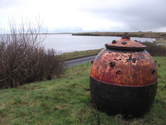
Just by the car park, is a …thing. Is it a massive fishing float? Or is it an old mine, from the war? It looks like a mine, to me – it’s perched up on a little mound, making it look all the more mysterious.

And this is where it all got interesting – at Inganess, there is the bay, with a beach, and, across the road from the bay, there is a walk, which can take you along by Wideford Burn, as described on the information board by the car park.

But – it was under water! The path, had become the burn, or vice-versa. The fields were just, flooded – here’s a selection of images to give you some idea…


The stile you can see, is supposed to give access to the path!
We met a man walking his dog along by the Bay, who says he’s been walking his dogs there, for 27 years, and had never seen it so wet. He pointed out that the waterfall on the left in this picture….

…isn’t always there, but it does appear, after heavy rain. However, he has never seen a waterfall where the second one, on the right, was now falling.
Inganess is known for the wreck of the ship Juniata https://canmore.org.uk/site/102376/juniata-point-of-grimsetter-inganess-bay-orkney-north-sea

Which has now been joined by another feature in the ocean there, a tidal turbine…
https://www.orkneyharbours.com/port-authority/info/notices/inganess-bay-ongoing

It’s not called ‘Underwater Hazard’ – it’s because – it presents one!
Putting them both together – the old and the new, at Inganess Bay.

The tide-line was right up to the sea wall – so, no walking on a beach for us, this time. Still, it was an interesting mooch – seeing all the flooding, meeting with friendly folk and their dogs. Not a bad way to spend a soggy Sunday.
One thing I feel I should mention is…there was an awful lot of dog dirt in the grass near the car park. There is a council sign, asking folk to clear up after their dogs, and there is a bin, to dispose of the offending article – but it looks like people just aren’t taking any notice. Maybe what’s needed is a slightly stronger worded sign, like this one, at Warbeth……..


Leave a Reply