
By Bernie Bell
We have a new neighbour, who has taken to Orkney like a duck to water. He appreciates the place, has a strong interest in the history and archaeology, and doesn’t mind the weather! He enjoys walking, and searching maps for new places to walk – looking ahead to when he’s allowed to do so.
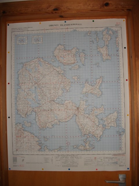
He had two copies of a map, originally published by the Ordnance Survey in 1959, and was kind enough to give us one of them. This is now pinned up on the door of the room known as The Office, and we pore over it….

Some things which were there, are gone, many things are now there, which weren’t there when this map was made – a lot more new houses for one thing, especially around Kirkwall and Stromness.
What is marked as ‘Aerodrome (disused)’, is now the Hatston Industrial estate, which, weirdly enough, includes a mound dating from the Iron Age, the Grain Earth House http://www.orkneyjar.com/history/earth-houses/grain.htm

This may have been part of a ’map’ of ancient Orkney – a place marker for the people of that time. It’s good that it has survived the construction of the aerodrome, and the Industrial Estate.
What is now Kirkwall airport, is marked as Kirkwall aerodrome – which is a different thing. By definition, an aerodrome is a location from which aircraft flight operations take place, regardless of whether they involve cargo, passengers…….. or military. Our map was, and I quote – ‘Published by D. Survey, War Office and Air Ministry 1960’. I don’t think Kirkwall airport is used by the Military, as such, these days!
I like the style of this map, it’s a more old-fashioned kind of map than what I’m used to, but not quite as different as those very old ones, which sometimes bear little relation to what can be found in the landscape, now. I used to have a map of Bradford, dated 1909, not much like Bradford now, or even the Bradford of my childhood. A difference which can be confusing, when the wanderer returns……… https://theorkneynews.scot/2019/08/26/solastalgia/
The scale of our 1960 map, is in inches and miles which I feel is a more ’human‘ measurement. It’s 1 inch to 1 mile or 1:63,360 – which is quirky, and maybe a bit awkward, like we humans are. A lot of 3’s – and three, is a magic number!
Today, maps use units based in physics – the metre https://en.wikipedia.org/wiki/Metre – and the nearest equivalent would be 1:50,000, or 2 centimetres to a kilometre.
Maybe easier to work with, but – I like quirky!
The map on the door, is along the hall from a map of Shala’s Orkney, taken from the ’Skara’ books by Andrew Appleby https://skarabooks.com/ , and represents the Orkney of pre-history, before the sea-levels rose, and what is now wet, was dry. A very different land/sea scape to today.

Maybe more akin to the landscape in which the Grain Earth House was raised?
I had further thoughts about how ‘human’ the old measurements are – an inch, was understood to be the distance between the first and second knuckle of a human index finger. A foot, strangely enough, was the length of a man’s forearm. A fathom, often used for measuring rope, was an arm-span. Not exactly precise – but….human. And, you didn’t need a tape measure or other equipment – it was all there, in a very portable form!
And, I nearly forgot, the Megalithic yard of Alexander Thom https://en.wikipedia.org/wiki/Alexander_Thom , for which Pete the Blacksmith https://wherethelightgetsin.co.uk/bluefoot-blacksmithing/ , has made a yard rule……..

Leave a Reply