
Continuing the topic of my island adventures, I mentioned in ‘Visit to Orkney’ (3rd July 2022) that in 1982 I had been the coordinator and navigator for an aerial archaeology flight. It all began with the Sighthill stone circle in Glasgow, which I had designed and created as Manager of the Glasgow Parks Department Astronomy Project in 1978-79. But it grew to take in sites in Argyllshire, the Inner Hebrides, Kintyre Peninsula, and the Firth of Clyde including Arran and Largs. My responsibilities had increased at every stage, but it wasn’t until the Cessna was taxiing towards the main runway of Glasgow Airport that I learned I was to be navigator – somewhat daunting, since my experience of light aircraft to date consisted of one five-minute hop round Turnhouse Airport in an RAF Chipmunk trainer, when I was in the Air Training Corps at 13 years old.

Since the first phase of the Sighthill circle’s construction had been completed by Royal Navy Sea King helicopter at the spring equinox of 1979, perhaps the escalation had been inevitable, but I didn’t see it coming. Ben Bova, then Science Editor of Omni magazine, had visited the stone circle in August 1979, while in the UK for the World Science Fiction Convention in Brighton. Ben commissioned an article from me, but after meetings with Dr. Bernard Dixon (Omni’s UK Editor, former Editor of New Scientist), and with staff reporter Kathleen McAuliffe, her article appeared instead in November 1981.2 It caught the attention of Leslie Banks, IBM’s UK head of scientific public relations, who invited me to IBM’s ‘Science and the Unexpected’ conference in March 1982. This was the first of nine extraordinary events, bringing together top scientists from the UK, from IBM’s scientific research institutes, and from a wide range of scientific fields, worldwide. All but the last of the events were held at the Excelsior Hotel, Heathrow, and looking out of the lobby at the ceaseless flow of touchdowns across the road, I was often reminded of a line from the early days of the Daily Express’s ‘Jeff Hawke’ strip: “When an airliner prangs on top of a conference of top-level scientists, it’s no accident!” Had it ever happened, science in the UK would virtually have come to a stop and the international community would have been severely damaged. Speakers who come to mind include Sir Hermann Bondi, Prof. Jacob Bronowski, Prof. Richard Dawkins, Dr. Richard Garwin, Prof. Thomas Gold, Prof. Stephen Jay Gould, Prof. Richard Gregory, Sir Fred Hoyle, Dr. Garry Hunt, Dr. Sergei Kapitza of the USSR, Prof. Eric Laithwaite, Prof. James Lovelock, and His Holiness the Dalai Lama. The late Prof. Archie Roy spoke on the origin of the constellation figures as ‘The Lamps of Atlantis’ in 1986, and was wearing his speaker’s tie when he was pictured with Dr. Howie Firth at the launch of Starfield, science fiction by Scottish writers, which I edited for Orkney Press in 1989. I was the only amateur scientist to address a Heathrow Conference, on ‘The Fermi Paradox’ in 1987, and Orkney News published an updated version of the paper in 24th April to 8th May 2022.3


Leslie Banks’s hobby was aerial archaeology, and he offered to photograph the Sighthill circle for me from the air. During the conference, he expanded his offer, asking if the dedicatees of the circle would have any requests for targets to be covered. When contacted, Prof. Roy, Dr. Archie Thom and Dr. Euan MacKie each had a particular request to make. For my part, as well as the Sighthill circle I was keen to include the standing stones on Colonsay, where I had made a partial survey of the standing stones in 1979. One of our major supporters on the stone circle project had been the late Dr. Graham Ritchie of the Royal Commission on the Ancient and Historical Monuments of Scotland, who traced the records of the project and lectured on them to the Archaeological Society of Glasgow in December 1981. Dr. Ritchie was also making a survey of the stones on Colonsay for more general research purposes, so he backed up my request for them to be included. But the Thatcher government had cancelled RCAHMS’s entire budget for excavations, much less for aerial photography, so he took our tentative flight plan round every department inviting requests. The result listed 18 targets at 12 locations, including Kilmartin Glen, Temple Wood, Kintraw and Euan MacKie’s excavations at Brainport Bay on Loch Fyne, all of which I had visited on the tour organized by the Astronomical Society of Glasgow in 1978. On top of all that we also had three target requests from the astronomy section of the Ayrshire Branch of ASTRA, then Scotland’s national spaceflight society. This was the point at which Leslie Banks agreed to lay on the aircraft and the photography, leaving all the rest of the organisation to me, starting by drawing up the suggested flight plan.
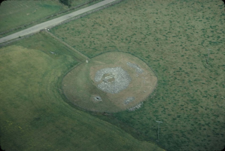
Sighthill Stone Circle

Sighthill stone circle, DL 1982 
Sighthill stone circle, Chris Stanley 1982
July 28th, 1982 started off bright and sunny, but there was haze moving across the country from the east coast. Driving from Wishaw to Glasgow Airport I came back into sunshine, but by the time the Cessna was in the air the airport and the city were overcast. We were not allowed to fly below 1500 feet over the city and the photographer, Chris Stanley, (winner of the 1981 Vinten Prize for aerial photography) doubted whether the Sighthill photos would come out – he couldn’t get a reading on his light meter at all. I had a Kodak Bantam Coloursnap Mark 1: the pictures taken under the overcast came out reasonably well, but Chris’s close-ups were impressive, and for the rest of the trip unsurprisingly he had the edge.
The Sighthill circle was now grassed over, but the bank on the south arc had never been stabilized and had now washed away downhill, so the stones on that side were once again too high to see over). To reduce costs, only the outer ring would be paved, plus the four decorative arcs, leaving the rest under grass; but I wasn’t there to supervise, and instead of recreating the bank the workmen flattened the contour of the site, leaving the stones on that side half-buried and much less spectacular, though it did look great from the air.
Brainport Bay


Euan MacKie’s request was for coverage of the shore site at Brainport Bay, near Minard, on Loch Fyne, where there is a long alignment of modified natural boulders, plus two sighting stones which were found with their wedging chips and had been re-erected in their sockets. The line looks up the loch to the midsummer solstice sunrise. Euan had asked for stereo coverage if possible, but that requires a special camera mounted under the wing of the aircraft and couldn’t be arranged. At Temple Wood and Kilmartin, we hit a different problem: the Sun angle was wrong and the only picture Chris obtained was of the Chambered Cairn at Netherlargie South. I photographed the nearby small circle, in which excavation had revealed a central kist, possibly the burial place of astronomer priests; but the detail was washed out by the reflected glare from the stone bed.
Kilmartin and Temple Wood


Graham Ritchie had listed several other sites in Argyllshire, but as I wasn’t familiar with them and time was passing, we made straight for Colonsay. Leslie let me take the controls in ‘fly-by-wire’ mode, on automatic pilot but overriding it, and I took us across the sea and through a preset descent on the approach to Balnahard Bay, on the north-west of the island. Over the brow of the hill to the south, Cnoc a’ Charragh (the Hill of the Standing Stone) there’s a very interesting stone with a slab beside it which covers an empty burial kist. When I first ‘found’ the site the Sun happened to be over a notch in the hills to the west, shining on the sea and revealing that at that point there’s a sea horizon. Rough bearings confirmed that it marked one of the dates in Alexander Thom’s postulated solar calendar dates.
Colonsay

We next tried for the small circle overlooking the microwave dish of the telephone exchange at Scalasaig, and the possible sites of two more which I had found. I thought that photographing them from the air, might reveal marks in the ground. But all of those stones are small ones, by megalithic standards, hard to see and briefly glimpsed from the air, even at 500 feet. I could see them because I knew precisely where to look, but Leslie and Chris could not. Admittedly I became better at giving directions as the flight went on, but in planning such missions these are points to keep in mind. There was no difficulty in spotting the conspicuous hilltop stone at Garvard, on the south end of Colonsay, although in the photograph it’s hard to distinguish from the sheep grazing around it. I had found a line of stones leading north from it through the valley, leading to a cairn overlooking the abandoned village north of Scalisaig, so it was obvious used for local navigation. As well as the alignment to it, its long axis face now points to two prominent notches between the Paps of Jura. The direction is towards midwinter sunrise, and to moonrise at furthest south. Graham Ritchie told me that the stone fell in the 1930s and was re-erected in 1960; I suggested that there might be older photographs against which its present alignment could be checked, but I’ve heard nothing further.


At Kilchattan on Colonsay there’s a real mystery: two very tall stones, perhaps 15 feet tall, placed crosswise in a valley so narrow that the hills, though low, rise high above them. The long axis of the valley points in one direction to a swamp, a loch and more hills, and to nothing striking in the other. Prof. Thom told me that he had visited the site but could make nothing of it. Graham Ritchie had found 17th century accounts of buried structures nearby, but we saw no marks with the naked eye or in the photos.
The rising of the west of Britain after the Ice Age has left Colonsay with tiers of raised pebble beaches in the south-west, and Graham Ritchie had asked us to look for Viking grave sites. However as we could see nothing and had many more sites to cover, we decided to press on. Each photo session involved circling for several passes, banking the aircraft and changing the undercarriage position to Chris’s direction: although the team shook down and became more efficient as the flight went on, taking pictures was a time-consuming business.
Oronsay

After we crossed the Strand, the ruins of Oronsay Priory gave Chris another target of opportunity which provided a spectacular photograph. South of the Priory Graham Ritchie had asked us to photograph mysterious mounds, obviously of human origin, which looked like burial sites, but nothing has been found within them. Subsequent excavation has found them to be Mesolithic middens, packed with fishbones and seashells.
Nave Island

On our approach to Islay, Graham had marked a feature by the ruined chapel on Nave Island as ‘Viking house?’. He hadn’t given it enough priority even to describe it in his accompanying notes, but it proved to be the find of the mission. Remains of several former structures could be seen and the ‘house’ itself is clearly boat-shaped; the island’s name may not relate to the chapel. The Vikings did build boat-shaped houses, but there may be a ship burial somewhere in the area: unusual numbers of brass rivets have been found in Viking graves on Oronsay, suggesting that a ship has been dismantled and the rivets used as currency. A key question about the age of the feature (which is less conspicuous at ground level) was whether it was crossed by the run-rig marks of Viking cultivation. If it was, the ‘house’ would be more recent; but in fact only one line crosses it and that one is much coarser than the run-rigs.
As far as I know, there has been no follow-up. The ‘Viking House’ near the chapel is listed as an ancient monument, but that seems to be all – it’s not mentioned on Wikipedia. Twice, when I’ve lectured on the aerial archaeology flight as a spin-off from the astronomy project, I’ve been approached by US travel agencies interested in organizing digs. But they were thinking of 20-30 people, whereas Graham Ritchie and Euan MacKie both said that if they were to investigate it, they’d begin with at least a couple of seasons employing one researcher and a couple of assistants.
Graham had asked us to photograph his excavations of Viking graves at Bowmore on Ardnave Point, but now we began to strike problems due to unfamiliarity with the sites. Luckily our photograph does show the trenches and vehicle tracks on the beach, and also an interesting polygonal feature in the grass, of which Graham was unaware. But now we had a succession of disappointments as we failed to recognize the targets requested: in one case where we knew we had to be in the right area, we photographed a natural hill and missed the archaeological targets to either side of it. But we did succeed by chance in capturing a circular hill-fort on Islay which was another of his requested targets.
I took the controls again between Islay and the Mull of Kintyre, and this time was allowed to cross the coast and make a turn, Leslie taking over when we asked permission to overfly Macrihanish, which was still a NATO airfield, now privatised. As he said, we must have surprised the radio operator, on such a peaceful summer afternoon. But we couldn’t find the standing stone to the south of it, and instead turned north to meet Archie Thom’s request at Pubal Burn, north of Campbeltown.
This time we showed that the camera can sometimes prove superior to the eye. In 1948 Archie had seen the marks of a circle in the crops, and subsequently the stump of a stone was found: he had been trying to get an aerial photograph ever since! We saw nothing from the air, but when the slide was projected on to a large screen, Christopher Taylor, a keen-eyed young member of ASTRA, found the faint marks of the former stones’ positions.
Tormore, Arran
Archie Roy’s request was the megalithic complex at Tormore, on Arran in the Firth of Clyde. From a stone to the south the double ring of Fingal’s Cauldron Stones – a perfect circle within a flattened one – lines up with the center of a flattened circle of the same shape to the north-east to mark the midsummer sunrise in a notch in the hills. All but one of the stones in the flattened circle have been reduced to stumps, but the survivor is 18 feet tall by 5 feet by 2, comparable with the larger blocks at Stonehenge. There’s also a small ring to the south of it. East of the flattened ring, another large circle or egg has been even more badly damaged and the remains of one stone still lie where it broke during an attempt to make it into a millstone. A single stone to the west, the centres of the two large rings, and the southernmost of two small ellipses to the east, point to sunrise at the equinoxes. The ellipses, found by Archie Roy himself and subsequently excavated by Aubrey Burl, were the first to be found in Britain. About 26 are now known, including Euan MacKie’s excavation of the Cultoon ring on Islay, showing that the ancient Britons had discovered the ellipse, 2000 years before the Greeks did around 600 BC.


Largs and Sir Thomas Makdougall Brisbane
As mentioned above, ASTRA, the Association in Scotland to Research into Astronautics, was founded (originally as a Scottish branch of the British Interplanetary Society) by the late Prof. Oscar Schwiglhofer, from Transylvania, in 1953. At that time Oscar’s astronomical research included the history of Sir Thomas Makdougall Brisbane, who had an observatory in Largs, Ayrshire, in the 19th century, before his appointment as Governor-General of New South Wales. An expedition organized by Brisbane discovered and named the river which in turn gave its name to the modern city. Brisbane’s catalogue of southern hemisphere stars is regarded as less valuable than Herschel’s, but his reputation on the continent is higher than it is in the UK – hence Oscar’s interest.

John Bonsor and Ron Williams of ASTRA’s Ayrshire branch independently started research into Brisbane’s activities in the 1980s, and had asked us to photograph the observatory site, as well as the “Three Sisters”, three large meridian pillars on a hilltop in the town, with which Brisbane’s three telescopes were lined up. Ron had also asked for coverage of a mediaeval village in the grounds of Hunterston House, adjacent to Hunterston nuclear power station. We thought we would be forbidden to overfly it, but did so unchallenged.

A last cautionary tale now emerges. I had passed Ron’s maps to Leslie but somehow they had become separated from the flight package – and I did not have a copy. Duplicate everything! Although Chris was well pleased with the chance to photograph the reactor buildings and the nearby Hunterston Ore Terminal, once again we couldn’t find the archaeological targets because we didn’t know precisely where to look. We gained a good shot of the Three Sisters, but I hadn’t been to the observatory at the time, and since I knew it was overgrown but didn’t know where it was, there seemed little point in searching.
Lecturing to ASTRA in January 1984, Archie Roy integrated the aerial photographs with his own shots of Tormore at ground level, to good effect. John Bonsor gave an entire lecture using only the Three Sisters shot, projected on to a plan of the Brisbane Observatory and its transit sight-lines. The various researchers all requested copies of the Tormore slides in addition to their own targets, and Graham Ritchie wanted copies of everything! Out of his 12 locations we had visited 8, drawn a blank at 4, been frustrated by the light conditions at one, but obtained potentially useful photos at three as well as ‘targets of opportunity’ such as Oronsay Priory. We photographed Sighthill and three of my targets on Colonsay, met Euan MacKie’s, Archie Thom’s, and Archie Roy’s requests, and also covered the main objective at Largs. The flight was a fascinating experience, and what contribution the photos will make to the various enquiries remains to be seen (even now).
It’s worth remembering, however, that my involvement in the flight and before it in the Sighthill project, stemmed originally from the enquiry by my colleague Alan Evans, about the possible significance of markings on aerial photographs of Stonehenge. Aerial views of Stonehenge and Avebury can be found in virtually every book on archaeoastronomy, but few of the other megaliths seem to be covered. Aerial archaeoastronomy may well have a great deal to add.
Dr. Euan MacKie, Hunterian Museum, Glasgow, by Gavin Roberts, 1978 Prof. Alexander Thom, Dr. Archie Thom (at rear), discussing Sighthill plan with DL,, Dunlop, by Gavin Roberts, 1979 Sighthill stone circle, DL 1982 Leslie Banks (centre) with Chris Stanley (left) and Cessna at Glasgow Airport, by DL, 1982 Sighthill stone circle, Chris Stanley 1982 Brainport Bay, Minard, Chris Stanley 1982 Brainport Bay long alignment, DL 1978 Brainport Bay sunrise marker, DL 1978 Kilmartin, Netherlargie S Chambered Cairn, Chris Stanley 1982 Temple Wood stone circle, DL 1982 Temple Wood stone circle and kist, DL 1978 Colonsay, Garvard standing stone, Chris Stanley 1982 Tormore Stones, Machrie Moor, Arran, Chris O’Kane c.1990 Kilchattan stones, Colonsay, Chris Stanley 1982 Jura from Cnoc Eibriginn, Garvard, Colonsay, Julian Paren, 1994 Mesolithic middens south of Oronsay Priory, Chris Stanley, 1982 Nave Island, supposed Viking House, Chris Stanley, 1982 Tormore Circles, Arran, Chris Stanley, 1982 Tormore Circle, Arran, Chris Stanley 1982 Fingal’s Cauldron Stones, Tormore, Arran, Chris Stanley 1982 The Three Sisters, Largs, Brisbane Observatory sighting pillars, Chris Stanley, 1982 Feature, Sir thomas Brisbane, Troon Times. 28th April 2015 Prof. Archie Roy (right), with Dr. Howie Firth, DL at rear, at the launch of Starfield, science fiction by Scottish Writers. Orkney Press, 1989
References
1. McAuliffe, K., ‘Explorations: Modern Megalith’, Omni, 3, 11, 118-120 (August 1981).
2. Lunan, D., ‘The Fermi Paradox’, Speculations in Science & Technology, 11, 1, 25-47 (January 1988); updated, Asgard, 4, 4, 27-41 (November 2002); Orkney News, 24th April, 1st May and 8th May, 2022.
3. MacKie, E.W., ‘The Prehistoric Solar Calendar: an Out-of-Fashion Idea Revisited with New Evidence’, Time and Mind: the Journal of Archaeology, Consciousness and Culture, 2, 1, 9-46 (March 2009).
4. MacKie, E.W., Professor Challenger and His Lost Prehistoric World, Archaeopress Publishing, 2020,
Lunan, D., ‘Archaeoastronomy from the Air’, Griffith Observer, 50, 11, 9-11 & 14-18 (November 1986).
5. Lunan, D., The Stones and the Stars, Building Scotland’s Newest Megalith, Springer. 2012.
Duncan Lunan’s book The Stones and the Stars, Building Scotland’s Newest Megalith, (Springer. 2012), is available on Amazon, through bookshops and from the publishers. For more details and for Duncan’s other books, see his website, http://www.duncanlunan.com.

Leave a Reply