
By Ian Cooper, from his excellent series Records of a Bygone Age published in the Stronsay Limpet and republished here with kind permission.
Turning again to the November 1849 article in the John o’ Groat’s Journal, part of which was quoted in the August edition of the ‘Limpet’, after commenting on the lands of Strenzie and highlighting the excellent agricultural practices of Rev Simpson on his Glebe land, the writer continues his report:
‘Turning eastward along the ridge of Stronsay I passed through an extensive tract of fine waste land, upon which small farms were dotted down at intervals; but though some improvements are here making, they are on a the very limited scale, and one regrets, after the proof of capability given by the minister, to see such land unproductive. There are here not less than 2,000 acres of land simply needing drainage and ploughing to give fine crops and productive employment to hundreds. Topping the easternmost part of the ridge I came at once upon two splendid farms, stretching along from Lambhead southwards on the east coast, from the storms on which they are protected by the grazing island of Auskerry lying parallel to them, about a mile and a half distant. These farms, Housebay and Holland, are uniformly of the finest quality of deep land, a good clayey loam, and they are farmed in a style that cannot be surpassed in any part of the kingdom. Housebay consists of 620 acres of arable, and, including 175 in Auskerry, has 570 acres of pasture.
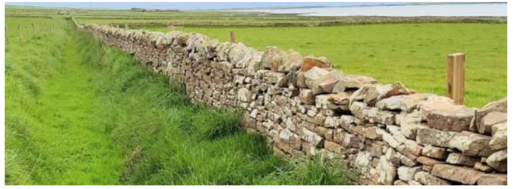
The arable land is enclosed by substantial stone dykes 5 feet high, with properly finished cope, set it in lime, and is divided into 18 fields of equal size, thoroughly drained, and has good roads, with ditches and flagstone fences subdividing it. The steading is extensive and the first I have met in the islands which seems built on plan. Indeed the whole improvement here are evidently of recent date and show that wonder-working power of a tenant of skill and capital, backed by a liberal proprietor. Immediately outside the fence dyke I found a dozen small tenants located, having new and improved cottage steadings; and I discovered that these were the former cottars of this large farm, who had been shifted here and made independent tenants, having squares off from 9 to 12 acres each, and paying rents from £4 to £6 in money. The manager informed me that these men were, with their families, willing labourers on wages, and by working along with experienced hands from Caithness, had become as good ditchers, quarriers, and dyke builders as their teachers, – in fact, greater part of the well finished work I saw was executed by Stronsay men; and almost the whole ploughmen on the farm were also natives.
A brief visit to the farm of Holland with its 500 acres of arable land followed, the property again finding favour with the author. While Housebay was under the ownership of a Traill laird, Holland had only recently become part of the Balfour estate and was under the tenancy of local man James Sinclair. The report stated that, while the farm was seen to be still in transition, everything was apparently well planned, was fast following in the wake of Housebay and, the writer believed, would be on a par with its neighbour in a very few years. On leaving Holland the author turned west, making his way along the central ridge of the island to the toonships of Aith and Grobister where he recorded that the farms in the districts:
‘are, or rather were, possessed by small tenants; for though the same men are retained, and no one, so far as I learned, removed by judicious squaring and laying off the ground among them, they have become the tenants of from 50 to 60 acres each. These townships are all fine deep land, with a fair slope and southern exposure. The farms are laid off in parallelograms from the ridge to the seaside, marked by deep, well cut ditches, and about mid way they are intersected by a formed road, having a deep ditch at each side, which serves to receive the water from the bounding ditches, and to conduct it to the outfalls. The road also divided each farm into a upper and lower fields, and a six shift rotation being strictly enforced by the proprietor, it was pleasing to see a 6 or 10 acre field of turnips on each farm and to find that these tenants – only just escaped from the old fashioned rundale, and all its lazy ways and prejudices – had the good sense to appreciate the benefits likely to accrue to them from the change, and were exerting themselves to prove the small-farm system the best.’
Moving forward a few years now it is well worth looking at the farm of Midgarth where I was born and, as I lived and farmed there for over 60 years, its history is of special interest to me. It is unusual in the fact that the fields on the whole farm are enclosed by drystone dykes, with the only other holding on Stronsay to be so enclosed being the previously mentioned Glebe land, now part of Hunton, where the fields were all enclosed by dykes in the 1830s. Few, if any, of these Midgarth dykes had been built by 1860, with an area of common land still to be found on the top of the ridge of land forming a division between the farms of Whitehall and Huip to the east and Midgarth to the west.

It was apparently a contractor from Sanday who was the successful applicant for building these Midgarth dykes, being paid the princely sum of 6d (2½p) a fathom for their erection. It seems rather strange that dyke building at that time was usually set at a price per fathom, a measurement of six feet (just under two metres) usually associated with sailing and the sea. This march dyke, around 3,000 yards in length, was to be a minimum of 4ft (1.2m) high, with the ‘ragstones’ (or cope) to be pointed with a mixture of lime and sand. Once the dyke marking the boundary of the farm was completed, attention turned to squaring off the land into fields of around 10 -12 acres and erecting dykes between them. A feature of a number of these dykes is that a ditch was first dug and then the dyke built on top of the spoil from the ditch. This was certainly a method that meant the dykes were built far quicker and required much less stone for their construction but also meant they were more prone to settlement and collapse.

Most of the field dykes in the southern part of the farm are built of stone quarried nearby, known locally as ‘grey whin’ or ‘blue whin’ while a number of dykes to the north west are red and yellow sandstone quarried from the low sandstone cliffs on the foreshore or from ‘oot o’ the ebb’ further down the shore.

All these original boundaries, whether flag fence or drystone dyke, if well constructed would have had little need of upkeep but, as time moved on, the need for regular maintenance of those dykes increased as foundations subsided, some of the poorer quality stone taken from near the surface in the quarries began to disintegrate or burrowing rabbits undermined the foundations. As with the drystone dykes, the flag fences also needed ongoing maintenance to keep them in good condition as they had a tendency to break off at the base or lean over due to subsidence, with larger breeds of cattle also utilising them as useful scratching posts and causing further damage. There are a good number of those flag fences still to be seen and, where they have been protected by a barbed wire or electric guard fence, many remain in reasonable condition and continue to provide good shelter for livestock.
Part 5 next month.
Leave a Reply