
By Ian Cooper, from his excellent series, Records of a Bygone Age, first published in The Stronsay Limpet and republished here with kind permission.
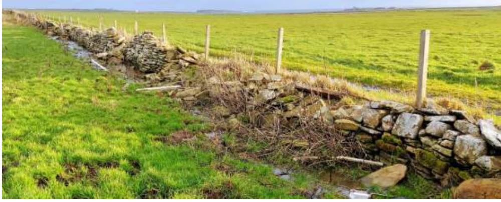
Last month’s article ended by highlighting the need for regular maintenance of both dykes and flag fences to keep them in good condition. When labour was plentiful, the maintenance of these would have been carried out during the winter months or slack periods during the summer, amounting to little more than replacing a few ragstones or straightening a flag or two. As time passed, guard wires, originally barbed wire but now more commonly electric fencing, was strung along the tops of the dykes to stop the cattle, ever increasing in number and size, from scratching themselves on the ‘rag stones’ (coping stones) of the dykes. This regular maintenance was essential as, if these stones were dislodged, then more of the dyke quickly followed and soon the animals would have a gap in the dyke where they could cross from one field to another, with this breach in the boundary steadily getting larger as stock moved unhindered between fields. As farms got larger and the workforce smaller, it became increasingly difficult to find time for this maintenance and there are a number of dykes in Stronsay where large sections have been flattened over the years by stock movement. Sadly it would now be a major task to attempt to rebuild them.

Not all is due to degeneration or neglect though, as nature can also play its part. There is a stretch of about 150 metres along the foreshore below Midgarth where the sea washed the dyke away, some of it a long time ago and the last stretch in the 1980s. This last stretch of about 50 metres was all rebuilt one summer, with the work being completed in July and the sea reclaiming it in a November storm. It hasn’t been rebuilt!
There are other sections below Whitehall, Odiness and Hescombe where heavy seas and high tides have destroyed some of the dykes and no doubt more will succumb to the sea as time goes on.


Yet one more reason for a dyke’s destruction came from a more unusual source, as recounted by my wife’s grandfather, the late James Chalmers of the Old Schoolhouse. He was a member of the Orkney Royal Garrison Artillery in the First World War and his unit was stationed for a time at a camp near the point of Linksness on Stronsay’s northwestern coast. This was where the telegraph cable from Stronsay headed over to Sanday and onward to Shetland and was a vital link in communication between the islands and also between these islands and mainland Scotland. The unit’s task was to protect the small telegraph building and the undersea cable in the event of an invasion. Stretching right across the promontory at this point was a substantial drystone wall, the march dyke marking the boundary between the farms of Linksness and the Ness. The artillery unit’s commanding officer decided that, in the event of an invasion, this dyke could be used as suitable cover for a German assault force to creep up on them, so decided the dyke had to go.
The unit set to with heavy hearts to demolish the dyke and, in just a few days, it was flattened to the ground. This wall was never rebuilt, much to James’ regret as he so much hated seeing such a good solid dyke destroyed. He then finished his story with a twinkle in his eye and the comment that ‘It must have been fairly effective all the same, as Stronsay was never invaded!’

Dykes utilising ‘cungles’ (large round sea-worn beach stones) are less common but there are still some great examples to be seen around Stronsay. This must have been a much more challenging raw material than the stones and flagstones previously mentioned and the most visible of these is the dyke at the Osen, where it encloses the garden and the field to the sea side of the farm. There is a similar section of dyke along the foreshore to the west of the Bu and it is testimony to the skill of the builders of both dykes that they are still standing and in very good condition today.


Much older example of dykes – possibly some of the oldest on Stronsay – can also be seen in Rothiesholm, out along the shore at Scaval and, less visibly, at Straenie Water.

Much of the Rothiesholm peninsula consisted of heather and peat which, in addition to providing fuel for the crofters’ fires, was common land used for grazing sheep. This area of hill ground was described in the Old Statistical Account of 1795 as being ‘a sheep walk of great extent’ and, with the narrow strips of land at Scaval and Straenie Water providing good natural funnels for gathering the sheep, it is highly likely that those stone built enclosures would have been in existence then. Although now slowly collapsing and becoming overgrown, much of the layout of the pens and enclosures at Scaval can still be identified but the passage of time and the effects of the sea has made that at Straenie Water less obvious’
Final part next month.

Leave a Reply