
By Steve Drury
PUBLISHED ON June 18, 2020
‘Everybody knows’ that mountains grow: the question is, ‘How?’
There is a tale that farmers once believed that they grew from pebbles: ‘every year I try to rid my field of stones, but more are back the following year, so they must grow’…
Geoscientists know better – or so they think[!] – and for 130 years have referred to ‘orogeny’, a classically-inspired term (from the Ancient Greek óros and geneia – high-ground creation’) adopted by the US geologist Grove Gilbert. It incorporates the concept of crustal thickening that results from lateral forces and horizontal compression.
Another term, now rarely used, is ‘epeirogeny’ (coined too by G.K. Gilbert), wherein the continental surface rises or falls in response to underlying gravitational forces. That could include: changing mantle density over a hot, rising plume; detachment or delamination into the mantle of dense lower lithosphere; loading or unloading by ice during glacial cycles. Epeirogeny is bound up with isostasy, the maintenance of gravitational balance of mass in the outermost Earth.

In 1990, Peter Molnar and Philip England pointed out that the incision of deep valleys into mountain ranges results in stupendous and rapid removal of mass from orogenic belts, which adds a major isostatic force to mountain building (Molnar, P. & England, P. 1990. Late Cenozoic uplift of mountain ranges and global climate change: chicken or egg? Nature, v. 346, p. 29–34; DOI: 10.1038/346029a0).
In their model, the remaining peaks are driven higher by isostasy. They, and others, coupled climate change with compressional tectonics in a positive feedback that drives peaks to elevations that they would otherwise never achieve. Molnar and England’s review saw complex interplays contributing to mountain building, accompanying chemical weathering even changing global climate by sequestering atmospheric CO2 into the minerals that it produces.
As well as the height of peaks in active zones of crustal shortening and thickening, such as the Himalaya, Molnar and England’s theory explained the aberrant high peaks at the edge of high plateaus that are passively subject to erosion. Examples of the latter are the isolated peaks beyond the eastern edge of the Ethiopian Plateau that locally have the greatest elevation than the flood basalts that form the plateau: unloading around these peaks has caused them to rise isostatically.
Thirty years on, this paradigm is being questioned, at least as regards active orogens (Dielforder, A. et al. 2020. Megathrust shear force controls mountain height at convergent plate margins. Nature, v. 582, p. 225–229; DOI: 10.1038/s41586-020-2340-7). Armin Dielforder and colleagues at the German Research Centre for Geosciences in Potsdam and The University of Münster consider that overall mountain height is sustained by interactions between three forces.
1. They are prevented from falling apart under their own weight or being pushed up further against gravity by lateral tectonic force.
2. Climate controlled erosion limits mountain height by removing material from the highest elevations.
3. Isostasy keeps the mountains ‘afloat’ above the asthenosphere.
The authors have attempted to assess and balance all three major forces that determine the overall elevation of mountain belts.
At a convergent plate margin where one plate is shoved beneath another, the megathrust above the subduction zone behaves in a brittle fashion, with associated friction, towards the surface. At depth this transitions to a zone of ductile deformation dominated by viscosity. A major assumption in this work is that stress in the crust below a mountain belt is neutral; i.e. horizontal, tectonic compression is equal to the weight of the mountains themselves and thus to their height. So, the greater the tectonic compressive force the higher the mountain range that it can support. The test is to compare the actual elevation with that predicted from plate-tectonic considerations. For 10 active orogenic belts there is a remarkable correspondence between the model and actuality. The authors conclude that variation over time of mountain height reflects long-term variations in the force balance, in which they find little sign of a climatic/erosional control. But that doesn’t resolve the issue satisfactorily, at least for me.
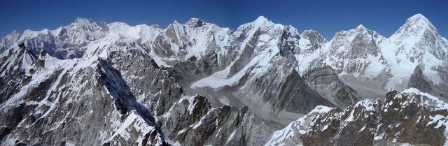
The study focuses on the mean elevation, and this leaves out the largest mountains; for instance, their maximum mean elevation for the Himalaya is about 5.46 km (in fact for a narrow NE-SW swath that may not be representative of the whole range). Yet the Himalaya contains 10 of the world’s highest mountains, all over 8 km high and 50 peaks that top 7 km, adjacent to the Tibetan Plateau. The mean elevation of the whole Himalayan range is 6.1 km. Consequently, it seems to me, the range’s maximum mean elevation must be somewhat higher than that reported by Dielforder et al. The difference suggests that non-tectonic forces do contribute significantly to Himalayan terrain
See also: Wang, K. 2020. Mountain height may be controlled by tectonic force, rather than erosion. Nature, v. 582, p. 189-190; DOI: 10.1038/d41586-020-01601-4
If you’d like to read more of Steve’s blog….. https://earthlogs.org/homepage/
Many thanks to Steve Drury for permission to republish his article and to Bernie Bell for sending it to The Orkney News


Leave a Reply