
By Steve Drury First PUBLISHED ON December 2, 2020
Britain is only an island when sea level stands high; i.e. during interglacial conditions.
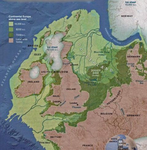
Since the last ice age global sea level have risen by about 130 m as the great northern ice sheets slowly melted. That Britain could oscillate between being part of Europe and a large archipelago as a result of major climatic cycles dates back only to between 450 and 240 ka ago. Previously it was a permanent part of what is now Europe, as befits its geological identity, joined to it by a low ridge buttressed by Chalk across the Dover Strait/Pas de Calais.
All that remains of that are the white cliffs on either side. The drainage of what became the Thames, Seine and Rhine passed to the Atlantic in a much larger rive system that flowed down the axis of the Channel. Each time an ice age ended the ridge acted as a dam for glacial meltwater to form a large lake in what is now the southern North Sea. While continuous glaciers across the northern North Sea persisted the lake remained, but erosion during interglacials steadily wore down the ridge.
About 450 ka ago it was low enough for this pro-glacial lake to spill across it in a catastrophic flood that began the separation. Several repeats occurred until the ridge was finally breached (See: When Britain first left Europe; September 2007). Yet sufficient remained that the link reappeared when sea level fell. What remains at present is a system of shallows and sandbanks, the largest of which is the Dogger Bank roughly halfway between Newcastle and Denmark. Consequently the swamps and river systems that immediately followed the last ice age have become known collectively as Doggerland.

Dredging of the southern North Sea for sand and gravel frequently brings both the bones of land mammals and the tools of Stone Age hunters to light – one fossil was a skull fragment of a Neanderthal. At the end of the Younger Dryas (~11.7 ka) Doggerland was populated and became a route for Mesolithic hunter-gatherers to cross from Europe to Britain and become transient and then permanent inhabitants. Melting of the northern ice sheets was slow and so was the pace of sea-level rise. A continuous passage across Dogger Land remained even as it shrank. Only when the sea surface reached about 20 m below its current level was the land corridor breached bay what is now the Dover Strait, although low islands, including the Dogger Bank, littered the growing seaway. A new study examines the fate of Doggerland and its people during its final stage (Walker, J. et al. 2020. A great wave: the Storegga tsunami and the end of Doggerland? Antiquity, v. 94, p. 1409-1425; DOI: 10.15184/aqy.2020.49).
The Storegga Slides
James Walker and colleagues at the University of Bradford, UK, and co-workers from the universities of Tartu, Estonia, Wales Trinity Saint David and St Andrews, UK, focus on one devastating event during Doggerland’s slow shrinkage and inundation. This took place around 8.2 ka ago, during the collapse of a section of the Norwegian continental edge. Known as the Storegga Slides (storegga means great edge in Norse), three submarine debris flows shifted 3500 km3 of sediment to blanket 80 thousand km2 of the Norwegian Sea floor, reaching more than half way to Iceland.
Tsunami deposits related to these events occur along the coast western Norway, on the Shetlands and the shoreline of eastern Scotland. They lie between 3 and 20 m above modern sea level, but allowing for the lower sea level at the time the ‘run-up’ probably reached as high as 35 m: more than the maximum of both the 26 December 2004 Indian Ocean tsunami and that in NW Japan on 11 March 2011. Two Mesolithic archaeological sites definitely lie beneath the tsunami deposit, one close to the source of the slid, another near Inverness, Scotland. At the time part of the Dogger Bank still lay above the sea, as did a wide coastal plain and offshore islands along England’s east coast. This catastrophic event was a little later than a sudden cooling event in the Northern Hemisphere. Any Mesolithic people living on what was left of Doggerland would not have survived. But quite possibly they may already have left as the climate cooled substantially
A seabed drilling programme financed by the EU targeted what lies beneath more recent sediments on the Dogger Bank and off the embayment known as The Wash of Eastern England. Some of the cores contain tsunamis deposits, one having been analysed in detail in a separate paper (Gaffney, V. and 24 others 2020. Multi-Proxy Characterisation of the Storegga Tsunami and Its Impact on the Early Holocene Landscapes of the Southern North Sea. Geosciences, v. 10, online; DOI: 10.3390/geosciences10070270).
The tsunami washed across an estuarine mudflat into an area of meadowland with oak and hazel woodland, which may have absorbed much of its energy. Environmental DNA analysis suggests that this relic of Doggerland was roamed by bear, wild boar and ruminants. The authors also found evidence that the tsunamis had been guided by pre-existing topography, such as the river channel of what is now the River Great Ouse. Yet they found no evidence of human occupation. Together with other researchers, the University of Bradford’s Lost Frontiers Project have produced sufficient detail about Doggerland to contemplate looking for Mesolithic sites in the excavations for offshore wind farms.
See also: Addley, E. 2020. Study finds indications of life on Doggerland after devastating tsunamis. (The Guardian, 1 December 2020); Europe’s Lost Frontiers website
If you’d like to read more of Steve’s blog….https://earthlogs.org/homepage/
Many thanks to Steve Drury for permission to republish his article and to Bernie Bell for sending it in to The Orkney News.


Leave a Reply