
“We tracked a plume of dust and water to a conspicuous dark patch high on a steep slope. This was the source of a giant landslide that triggered the cascade of events, and caused immense death and destruction.”
Dan Shugar, associate professor at the University of Calgary.
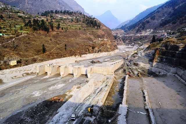
On February 7 2021, the Chamoli district in the Uttarakhand region of India experienced a humanitarian tragedy when a wall of rock and ice collapsed and formed a debris flow that barreled down the Ronti Gad, Rishiganga, and Dhauliganga river valleys.

The massive slide, caused when a wedge of rock carrying a steep hanging glacier broke off a ridge in the Himalayan mountain range, and the resulting debris flow, led to the destruction of two hydropower generating facilities and left over two hundred people dead or missing.
Initial suggestions pointed to a glacial lake outburst flood. There are no glacial lakes of any size large enough to produce a flood anywhere near the site.
A self-organized coalition of fifty-three scientists from 14 countries came together in the days following the disaster to investigate the cause, scope, and impact of the flood and landslide.
David Shean, a University of Washington assistant professor of civil and environmental engineering described what happened.
“On the morning of the event, I was reading the news over coffee, and saw a headline about a disaster in the Himalayas.
“I sat down at the computer and pulled up the satellite images that had been acquired that morning. When I saw the dust cloud moving down the valley, I started writing emails to other scientists asking if they were working on this. One email thread quickly became five, then 10, and the response effort consumed most of our waking hours for the next two weeks.”
The researchers compared the images and topographic maps from before and after the event to document all of the changes and reconstruct the sequence of events.
“We tracked a plume of dust and water to a conspicuous dark patch high on a steep slope,” said Dan Shugar, associate professor at the University of Calgary.
The dark patch turned out to be the scar left by the 35 million cubic yards of missing rock and glacier ice with a half-foot-deep layer.
“This was the source of a giant landslide that triggered the cascade of events, and caused immense death and destruction,” said Shugar.
The researchers also used the maps to determine how far the block of ice and rock fell. It fell over a mile. Then the larger team was able to quantify how the pulverized rock and ice were redistributed over the downstream areas.
“As the block fell, most of the glacier ice melted within minutes. This resulted in a huge volume of water associated with the flooding,” Shashank Bhushan, a UW doctoral student in civil and environmental engineering, said.
“This is highly unusual — a normal rock landslide or snow/ice avalanche could not have produced such huge volumes of water.”
For Bhushan, who has family and friends in India, the work was personal .
The team also used satellite image archives to show that previous large ice masses had been dislodged from the same ridge and struck the same valley in recent years.
Understanding the causes might help to prevent future disasters.
“These high-mountain rivers are appealing for hydropower projects, and we need a better understanding of the full spectrum of potential high-mountain hazards,” Shean said. “We hope that lessons learned from this effort will improve our ability to respond to future disasters and guide policy decisions that will save lives.”
High resolution satellite imagery used as the disaster unfolded was critical to helping to understand the event in almost real time.
Their study, which analysed satellite imagery, seismic records, and eyewitness videos to produce computer models of the flow, was published online in the journal Science.
The study provided satellite evidence that previous large ice masses had been dislodged from the same ridge and struck the same valley area in recent years. The researchers suggest that climate change is contributing to such events happening more frequently, and that the greater magnitude of the latest disaster is an argument in favour of avoiding further developments in the area.
The funding of the research came from multiple sources including: the NASA High Mountain Asia Team and the Future Investigators in NASA Earth and Space Science Technology fellowship;government agencies including those in India, Canada, France, Germany and Switzerland. The satellite imagery the UW team used was provided by MAXAR, Planet, ISRO and CNES, the French government space agency.


Leave a Reply