
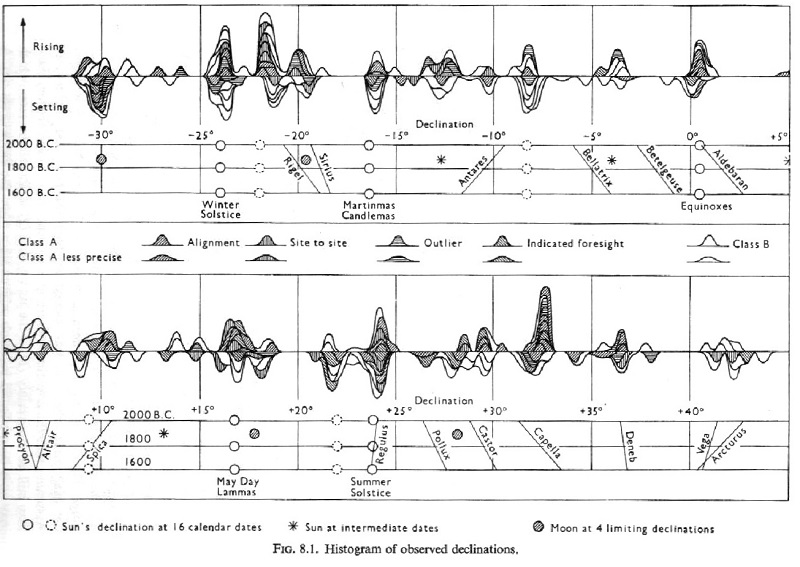
This piece of research has been hanging fire for years. The original diagram, a histogram of the alignment of ancient Neolithic sites in relation to events in the sky, was published by the late Prof. Alexander Thom in his Megalithic Sites in Britain (Clarendon Press, Oxford, 1967), and it’s been reproduced many times, for instance in the late Dr. Euan MacKie’s account of his own work in relation to Thom’s, Professor Challenger and His Lost Neolithic World (Access Archaeology, 2021). Most of the subsequent discussion has related to the solar and lunar alignments, but the histogram also includes the brighter stars visible from Britain, from Antares in the south to Arcturus, which is the brightest star north of the Ecliptic (the plane of the Earth’s orbit, consequently the Sun’s apparent path in the sky through the year).

Prof. Thom’s book predated the revolution in archaeology which came with the revision of the radiocarbon carbon dating scale in 1977. Before that, it was thought that the major epoch of megalith building in the UK had been between 2000 and 1600 BC. The revision pushed the start of work at Stonehenge to c.2900 BC, with everything else moved accordingly, putting Newgrange and the other great passage tombs of the Bend of the Boyne, the Stonehenge Cursus and the Ring of Brodgar all prior to 3000 BC.
The effect on the solar and lunar alignments was minor. The tilt of the Earth’s axis, also called ‘the obliquity of the Ecliptic’, changes with a period of 40,000 years, but c.3000 BC it was near its maximum value of 24 degrees, so solar and lunar alignments to either side of that date are still close to those positions. But the situation with the stars is different. The Earth’s axis also has a wobble with a period of 26,000 years, due to the pull of the Sun and Moon on the Earth’s equatorial bulge, and the result is that the north celestial pole traces a circle in the sky with Polaris on one side of it, and Vega in the constellation Lyra on the other. Different stars are close to the pole at different times: during the building of the great pyramids, for example, 2650-2500 BC, the pole star was Thuban in the constellation Draco. The declinations of the stars, which are the latitudes on Earth where they pass overhead, are therefore constantly changing, and star atlases have to be constantly updated. When I was a student, the maps in the edition of Norton’s Star Atlas which we used were ‘Epoch 1950.00’.
Euan MacKie asked in one of his papers how the star alignments would be altered by the revision of the radiocarbon dates. By a process of elimination, that would have probably have been in his paper ‘Wise Men in Antiquity?’, for the book Astronomy and Society in Britain during the Period 4000-1500 BC, edited by C.L.N. Ruggles & A.W.R. Whittle (BAR British Series 88, 111-152, 1981). I no longer have that because in 2017 I donated my entire collection to the Library of University College, Cork, in anticipation of a move to southern Ireland which didn’t come off.
From a visual inspection of Thom’s histogram, I said in my book The Stones and the Stars, Building Scotland’s Newest Megalith (Springer, 2012) that it looked as if the alignment of the stars with the stones might be improved if the stones had been erected earlier. There were many reasons why I didn’t pursue it at the time – a major one was that I had a contract with Springer to follow the book with Incoming Asteroid! What could we do about it?, and another was that just after The Stones and the Stars came out, it was announced that the Sighthill megalith which I had built for Glasgow Parks Department in 1978-79 would be destroyed, so starting the campaign to save it, now near a successful conclusion. But the main reason was the sheer amount of work which would be involved. Prof. Thom’s histogram proceeded upwards in 200-year increments, so for each extension of it I would have to recalculate the position of the celestial pole, then recalculate the declination of each star by spherical trigonometry, 2-3 pages of calculation for each – as he must have done, back in the 1950s and 60s.
By the spring of 2016, in response to a public campaign which gained 6,500 signatures, Glasgow City Council agreed that the Sighthill stones would be preserved, when the site was cleared for redevelopment of the area. By the summer of 2017 we had agreement on a new site for them, overlooking Pinkstone Road instead of the M8 motorway, and at the summer solstice of 2018 my colleague Gerry Cassidy and I observed midsummer sunset at the new site, giving me the start point for the new design. I had to recalculate the alignments for the stones, given that they would now be several hundred yards further east and about a hundred feet lower. As I had done the first time, the basic calculations for the true horizon would be relatively easy, but to estimate where the rising and setting tracks would cross the actual horizon, also taking atmospheric refraction into account, would be a huge task if I still had to do it all by spherical trigonometry. Fortunately, the available technology had moved on.
Software which I had used in the 1980s and 1990s was either now obsolete or not usable without expensive upgrades. I bought a well-known brand of current astronomical software which for some reason, I found exceptionally hard to use. The answer proved instead to be the new ‘Interactive Sky Chart’ on the website www.heavens-above.com (highly recommended), using which I was able to plot the track for each event in increments of a minute of time and a minute of arc. Using the same technique to reconcile the observations of the events at the previous site, over the previous 40 years, provided a useful shortcut, and I had only to plot the results on Gerry’s ‘working photographs’ of the horizon, to determine the new azimuths for each stone. It took about a month, all told.
With that done, my mind turned to Euan MacKie’s question. I had already established, to my disappointment, that the expensive software I’d bought didn’t go back far enough to do it, even if I could have got it to work, and now I found that the Heavens-Above interactive chart didn’t even go back into dates BCE (Before Christian Era). Just when I seemed to have reached an impasse, Avanquest Software Publishing UK brought out a new Version 8 of Redshift, whose Version 3 I had used in the 1990s, and Redshift 8 does indeed go back to 4713 BC, far enough for this purpose.
I won’t list the reasons why I still haven’t done it till now – suffice it say that they include yet another house move, and the publication of my 10th book. When I agreed on this series of articles with Fiona Grahame, I thought I would publish it to mark the reopening of the Sighthill circle at last year’s summer solstice, but Covid has delayed the work in the area so much that no reopening date is yet in sight. It wasn’t convenient to fit it into the sequence at last year’s autumn equinox or winter solstice, but with the spring equinox just past, and the cosmology articles just finished, ‘Time by the Stars’ last week has given me a good preamble to doing it now.
So here we have it – and as far as I know, nobody has done this before, so Orkney News has a scoop here – “unless of course you know differently”, as Esther Rantzen used to say. Using Redshift 8, I have plotted back the declinations of all the bright stars in Prof. Thom’s histogram, all the way to 4000 BC, which takes us right through the megalith-building era, including the cursi and the Irish passage graves. The first piece of good news was that all of Thom’s calculated declinations proved to be correct, as indicated by my crosses on them on the 2000 AD line. Almost all the tracks plotted by him as straight lines, curve as we go back through time, to greater or lesser extents, as they should do: although the stars are relatively fixed on the celestial sphere, the way in which their declination varies as the Earth wobbles beneath them will be different from one star to the next.


Mythology provides one interesting proof that we’re on the right lines (as it were). On the south half of the chart, the plots for Betelgeuse, Bellatrix and Aldebaran all cross the plot for Antares going in the opposite direction. That is as it should be, because Betelgeuse and Bellatrix are the shoulders of Orion (can you hear that without thinking of Bladerunner?), braced to receive the charge of the Bull, whose red eye is Aldebaran. Antares is the red heart of the Scorpion, who killed Orion, and was placed by the gods on the far side of the sky from him to prevent any further bother. Only when plotted in declination do their paths cross.
I don’t make any claim to beauty or elegance of the diagrams – despite the efforts my wife Linda and I have made to clean up the unwanted pencil marks and lines. The points where declinations cross, like those of Capella and Regulus in 3500 BC, were particularly difficult and needed initials added for clarity. I didn’t plot the path for Castor because it would complicate the upper curves for Regulus, Pollux and Capella still further. I haven’t prolonged all of Thom’s ‘star-lines’ because it would turn the diagrams into spiders’-webs, making it hard to see the pattern – if there was one. But there is no pattern: the real surprise is that there is no surprise.
There is no multiple alignment of stellar declinations with histogram peaks – no epoch in which they fit better than they do at the foot of the diagram. Where they do line up, it’s because Precession of the Equinoxes has taken the stars through significant solar declinations such as the solstices, equinoxes, the cross-quarter days and intermediate ‘calendar dates’ which Thom marked on the 1800 BC line of his diagram with stars and filled circles. The dates when those coincide with star declinations are scattered at random through the preceding 2200 years. Let me emphasise what this means:
The only epoch in which standing stones are meaningfully aligned with the bright stars is c.2000 BC, with a spread of at most 200 years both before and after.
By chance, the too-early radiocarbon dates led Alexander Thom to a further discovery whose significance doesn’t become apparent until viewed against the greater spread of declinations over time. And once that’s recognised, the reason for it is not hard to find. The highest peak of all in the histogram, marking the greatest number of alignments – even greater than for the midsummer and midwinter sunrises and sets – is for Capella, the brightest star in the constellation Auriga, c.2000BC. And as Thom pointed out in Megalithic Sites in Britain, that was when Capella became circumpolar, ceasing to rise and set, and remaining in the night sky all year round thereafter. (Note that Deneb, Vega and Arcturus were all circumpolar in the British Isles throughout. The small cluster of alignments above + 40 degrees, which Euan MacKie regarded as ‘doubtful’, look a lot more significant in this context.) Thom believed that the complex layout of The Hill o’ Many Stanes at Mid Clyth had been created to let observers track the Capella event in detail. In his second book, Megalithic Lunar Observatories, he re-interpreted it as a lunar observatory; but once a complicated observing grid had been laid down, it could easily be used for other purposes.


In Megalithic Lunar Observatories, Thom argued that the ancient observers had become fascinated by the detailed movements of the Moon, perhaps in relation to prediction of eclipses, and the complexity of alignments in Kilmartin Glen, Argyllshire, reflected that interest. The further north the observing site, the more those subtle shifts in lunar declination would be spread out on the horizon and more easily identified. Finally on the island of Unst the Moon would become circumpolar at its extreme northerly position, and that is marked by a stone circle – not an ellipse or an egg-shape, as so many stone rings are. At that point, Thom concluded, the ancient builders must have realised that the world was round.
Capella’s becoming circumpolar would be dramatic confirmation of that. And because its position in relation to the other stars of Auriga hadn’t altered, nor Auriga’s in relation to the surrounding constellations, it had to mean that the whole sky was slipping, or that the polar axis was moving away from Thuban. However they interpreted it, the Neolithic watchers had discovered the Precession of the Equinoxes.
Objectors may say that we can never know what actually went through those people’s minds, and at best the standing stones can only indicate that they might have discovered Precession. I’m happy to accept that qualification, as part of the ongoing argument about what the stones tell us about the thought-processes of the builders. I had quite a bit to say ab out that in The Stones and the Stars. For the moment I rest my case, not least because all of this has been done in five days’ intensive work. But if nobody has done it before – remember, you read it first in Orkney News!
The Stones and the Stars, Building Scotland’s Newest Megalith, by Duncan Lunan, is published by Springer, New York, and is available through the publishers, from bookshops and through Amazon. More details are on Duncan’s website, http://www.duncanlunan.com.


Leave a Reply