
An updated FLOOD ALERT has been issued for Orkney.
A combination of spring tides, a surge, wind and waves could cause coastal flooding impacts around Orkney on Monday and Tuesday. Potential impacts could include localised flooding of land and roads, and isolated flooding of properties. The risk will be greatest around the times of high tide, which at Kirkwall occurs around 23:00 on Monday, 11:15 on Tuesday, and 00:00 on Wednesday.
Remain vigilant and remember, it is your responsibility to take actions which help protect yourself and your property. Advice and information is also available through Floodline on 0345 9881188. This FLOOD ALERT UPDATE is now in force until further notice. If you haven’t already signed up to receive free flood messages, please call Floodline or register online at Flooding Sign Up.
Your Floodline quick dial number for this area is 22500

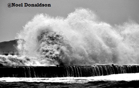
Churchill Barriers
A combination of high tides and strong North-westerly winds means that there is a high risk of wave overtopping and hazardous conditions at the Churchill Barriers during the next 24hrs. Road closures are likely around the time of the high tides which are between 21:15 and 23:15 GMT on Monday 3rd and 10:00 and 12:00 GMT on Tuesday 4th. To find out if the barriers are currently closed or open, please follow https://twitter.com/OIC_Roads
Your Floodline quick dial number for this area is 22513
Kirkwall
A combination of high spring tides and strong north westerly winds means that wave overtopping is likely in Kirkwall around the harbour and Weyland Bay. Orkney Islands Council may need to close flood gates around the harbour.
Please follow any announcements from the council https://twitter.com/OIC_Roads.
Any vehicles at the harbour or the Ayre Road car park which are on the seaward side of the sea wall should be moved if possible and safe to do so. Large and overtopping waves are expected and in places could cause hazardous unpredictable conditions. The highest risk will be a few hours either side of the next high tides at 23:15 GMT on Monday 3rd and 11:15 GMT on Tuesday 4th,with the highest impacts forecast to be on Tuesday mornings high tide.
Your Floodline quick dial number for this area is 22501
St Margaret’s Hope
A combination of spring high tides and strong north-westerly winds means that there is a risk of coastal flooding of Front Road and Pier Road along with properties to the seaward of these roads. Large and overtopping waves are expected and in places could cause hazardous and unpredictable conditions. The highest risk will be a few hours either side of the high tide at 09:45 GMT on Tuesday 4th.
Your Floodline quick dial number for this area is 22519
Stronsay
A combination of spring high tides and strong north-westerly winds means that there is a risk of coastal flooding in Stronsay. Any low lying coastal roads and properties across the island exposed to the prevailing wind will be subject to significant wave spray impacts. Waves overtopping roads, harbour and foreshore may lead to hazardous and unpredictable conditions. Northerly winds place houses facing the harbour in Whitehall at particular risk. The highest risk will be a few hours either side of the high at 11:45 GMT on Tuesday 4th.
Your Floodline quick dial number for this area is 22525


Leave a Reply