
After our visit to Machrie Moor in August last year (ON, 25th August 2024), we’ve had plenty of suggestions for more places on Arran to visit. Weather and a bout of flu apiece have prevented Linda and me from getting to any of them until now, but with the coming of spring we’ve taken up the first suggestion, and added two more, with the help of local guide Keith Robertson.

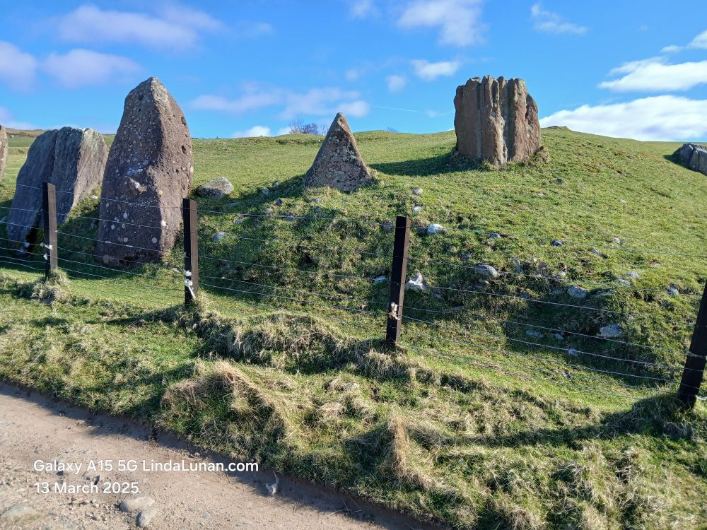
That first suggestion was the stone circle at Auchengallon or Auchagallon, not far from Machrie Moor itself (Fig. 1).

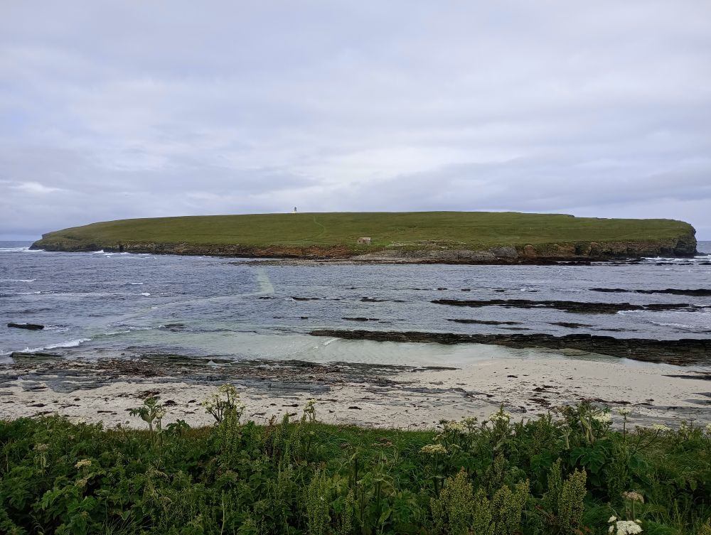
It’s reached by a fairly steep uphill track (Fig. 2) from the road branching off from the A841 circling the island, and from it there are dramatic views over Kilbrannan Sound (Fig. 3).

The ring itself encloses a grassy mound with the stones embedded in its perimeter (Figs. 4 & 5), with those facing the sea on the west appreciably larger (Figs. 6 & 7) than those on the east (Fig. 8). And after that it gets complicated.


The Historic Scotland plaque is quite definite that this is a cairn surrounded by a ring (Fig. 9), and so is the Ordnance Survey Explorer map, which unequivocally marks it ‘Cairn’.

However, Horace Fairhurst’s Exploring Arran’s Past (Isle of Arran Museum Trust, 1999 edition) states “One of these [western slabs] is closely fitted between the other two and has a relatively flat top… Now this type of ‘recumbent circle’, as it is called from the flat topped slab, is found commonly in Aberdeenshire, Perthshire and South West Ireland’. If it were true, it would clearly indicate an astronomical role, because the recumbent circles are placed so that the Moon will roll along the top of the slab at its furthest south (Fig. 10).


But the three stones in question (Figs. 11 and 12) are in the west, not the south, nothing like as closely grouped as the central feature of the Tomnaverie circle in Aberdeenshire (Fig. 9) or the oddly isolated one which I found on Colonsay in the late 70s (Fig. 13), and although the stones at Drombeg in County Cork are more widely spaced (Fig. 14), the function of the central one is far more obvious (Fig. 15).


Fairhurst is on stronger ground when he adds ‘a cist is said to have been found within the circle’. A cist for cremated remains is likely to have been at ground level; Geoff Holder’s The Guide to Mysterious Arran (The History Press, 2021) adds more, drawn from J.A. Balfour, ed., The Book of Arran, Vol. 1, (Arran Society of Glasgow, 1908), which is available for reading at the Internet Archive (archive.org) website. (Don’t be diverted to Vol. 2, which is archived separately and concerns more recent history.)
Balfour’s text reads, ‘The area within the ring of stones is now entirely filled by small rounded stones [and now grassed over – DL], so that the monument has the appearance of an encircled cairn [my emphasis]. Mr. Archibald Sim, who has lived a long life in the near neighbourhood, informed us, however, that in his youth the enclosed area was flat and filled with stones. The ground is cultivated all round the circle, and the stones gathered from the fields have been piled year after year within it, until now a number of upright stones are actually hidden below them. Mr. Sim told us that he remembered well seeing the circle excavated at the centre many years ago. A stone cist, he said, was exposed and opened, but he could give no information about its contents. In these circumstances, and considering the great recent elevation of the surface, a projected attempt to explore the circle was abandoned.’ Attractive as the site currently is, one could wish they’d continued. Discussing the stones on site, Keith Robertson and I both had the impression that there could be a lot more to them below ground – like some of the statues on Easter Island (Fig. 16), though Fig. 17 is an extreme example.


If the interior of the circle was originally flat, and covered with stones, it would resemble the small excavated circle at Temple Wood in Kilmartin Glen, Argyllshire (Fig. 18).

There’s a cist there too, and although it’s near the great lunar observatory, it has no astronomical alignment. At the time when the Sighthill stone circle was built, and landscaping it was under discussion, it was originally proposed that it be floored with ‘Cossie sets’ to echo the Temple Wood layout. As economies took effect it was decided to fill much of the interior with beds of grass instead (Fig. 19), and then to grass it all, with cossie insets, as was finally done before it was photographed from the air in 1982 (Fig. 20).


At its new home overlooking Pinkstone Road, the interior of the circle (preserving the soil where many people scattered their loves ones’ ashes) has been left to grass and wild flowers (Fig. 21).

If properly conducted, the central excavation should have established whether Auchengallon is a mound or a cairn. Cairns are purposefully constructed and structured, with chosen stones, whereas material in a mound is simply dumped in a heap. After excavation of the huge cairn at Kintraw in Argyllshire, in 1978 Dr. Archie Thom and others were angered when it was not rebuilt but instead the stones were simply pushed together with a bulldozer. It shouldn’t take too much of a slice into Auchengallon to establish the point now.

Although we had booked only for the Auchengallon visit, Keith Robertson suggested that we also visit the Druid Stones at Auchencar, within striking distance further up the A841 (Fig. 22). They’re reached by a side road leading to the Old Byre shop and the Café Thyme restaurant, where we had an excellent meal afterwards. Like the Lighthouse at Pirnmill, and the Crow’s Nest at Shiskine, to both of which we’ve now been, it’s modern and spacious, with dramatic views of the sea and the Kintyre Peninsula. The tallest standing stone in Arran is easily seen on the way up, and reached by a short walk across the field.
Walking towards it, it looked very familiar, though on a much larger scale. On the island of Colonsay in the Inner Hebrides, at Balnahard Bay on the northeast, there is a ruined, early Christian chapel known as Cill Chaitriona. Local tradition says it was founded by monks from the first phase of monastic settlement on Iona, between 600 and 800 AD, or if from the second phase of monastic activity there, it would be after 1200. It struck me as a sad place: near the chapel is an angled stone called the Clach A’Pheanais, or The Penance Stone, which was used by nuns for flagellation in what is still called ‘the Glen of the Sorrowful Women’ (Fig. 23).


In the graveyard there’s a ‘shouldered cross’ (Figs. 24 & 25), which local tradition says represents the Virgin Mary – credibly so, especially from some angles. Although the figure is only waist-high, and the Druid Stone is 3 metres tall (Fig. 26), the resemblance is striking.

On Colonsay, one of the targets we photographed on the aerial archaeology flight in 1982 was two very large stones at Kilchattan called ‘Fingal’s Limpet Hammers’ (Fig. 27).

Located in a valley between high hills, their function was not apparent and Prof. Thom was baffled by them on his brief visit to Colonsay (see ‘Archaeoastronomy from the Air’, ON, July 17th, 2022). Canmore, the website of the National Record of the Historic Environment, now says that they were part of a 48.5 foot stone circle. The Druid Stones, too, were originally a pair, and the fallen one (also ‘shouldered’) still lies where it fell (Fig. 28).

But as Keith Robertson said, the Druid Stones must have made a magnificent gateway when both erect, and they would have framed a prominent notch in the hills (Fig. 29).

Though only approximate, a wristwatch bearing puts it due east, the site of equinox sunrise in March and September, also multiply covered by and from the circles of Machrie Moor (‘Visit to Machrie Moor’, above).
As we’d done one extra target, I asked if on the way back we could also visit a small stone circle at the high point of the road from Brodick to Lamlash. I’d been seeing it last spring and over the winter, though in summer it was hidden by new growth. Curiously it doesn’t seem to have a name or a nickname: the footpath passing it is signposted ‘Claunchland Hills’ and one of the Arran websites refers to it as in ‘Blairmore Glen’, but the circle itself is always labelled ‘Lamlash-Brodick Road’ or ‘Hill’, as in Fig. 1. It’s not clear why because although it’s small, it’s one of the most attractive circles I’ve been to. Up the walkway, an unmarked path to the left zigzags past a view point with a picnic table, again with no signage I could see, before going right across a wet patch to the ‘outlier’ 22 yards before the circle itself (Fig.30). Then things get complicated.

I’ve been told by a local resident that the circle was originally where the road is now, and was moved to make way for it. There’s nothing about that in any of the four books I’ve consulted, nor any of the websites. As a stone circle builder, I would have wanted to put it on top of the hill from the outset, not on the lower level of the road (Fig. 31).

And Balfour states, ‘In its centre is a flag which covers a cist… rudely cut into the sandstone rock. This cist was opened in 1861 by Dr. James Bryce, and was found to contain black earth and fragments of bone, apparently burnt. In the soil above the cist a few flint flakes and a flint implement were picked up, but there were no relics in the enclosure itself.’ (If only they had known about radiocarbon dating, back then!) The cist isn’t shown on the plans below, so we can’t tell if this was before or after the road went through, but the road was built in 1810 and it seems unlikely that the road-makers would have dug a new cist to be excavated in 1861 – but see below.
Then things get stranger. In The Guide to Mysterious Arran, Geoff Holder writes, ‘Horace Fairhurst, in Exploring Arran’s Past, says that there were originally seven stones, and indeed there are seven now. But thereby hangs a tale. The Book of Arran 1 has a pre-First World War photograph of the circle in open moorland with brilliant views. The accompanying plan clearly shows four stones [Fig. 32], and the positions of the missing three.

The three large uprights and the big fallen boulder are the original stones, the three smaller ones have been added some time in the twentieth century by person or persons unknown. [Can this be the origin of the story that the whole circle was moved? – DL] The cist is no longer visible’.


Fig. 33 is the plan in The Book of Arran 1, (notice how large the magnetic variation was then), and in Exploring Arran’s Past, the corresponding plan clearly shows the ambiguous figures of Fig. 33 as actual stones (Fig. 34). So as Fig. 33 shows the sockets of the missing stones on the perimeter as crosses, are the shapes inside the circle two of the other three stones which were there all along? (Notice that there are still seven stones only if you count the outlier.) Although Balfour says that there are only four stones, he doesn’t mention the outlier, and my money says that the small ones were there too, if only because they look as if they belong there (Figs. 35 & 36).


I have to say, I have difficulty in believing that ‘person or persons unknown’ took the trouble to find matching stones, haul them up there (no vehicle access) and put them in just the right places. Perhaps those stones were never put into place on the perimeter because construction was interrupted; Euan MacKie found a similar situation at Cultoon on Islay. (See his Professor Challenger and His Lost Neolithic World, Archeopress, Oxford, 2020).

The outlier (Fig. 37) is obviously the one to look at for astronomical alignment. Unfortunately the skyline behind it, which appears to include a hill, is now obscured by trees (Fig. 38), and so is the one to the northwest (Fig. 35), though it can be seen, along with the circle, from the viewpoint (Fig. 39).


That the outlier is opposite Goatfell is a help: that gives it an azimuth from the centre of the circle of approximately 155 degrees East, further south than even moonrise at furthest south, in Neolithic times, and not obviously significant, unless the skyline behind the trees is well above the true horizon.

However, measuring the azimuths of the circle stones produces a very different result (Fig. 40), casting doubt on the age of the whole structure. Lest I be accused of always being able to find one, it has to be said that none of them has any obvious astronomical significance. What Figs. 33 & 34 artfully conceal by their orientation is that the structure is almost entirely symmetrical, with stones A and D paired at 130 degrees east and west, and stone B and socket 2 at 80 degrees east and west. Socket 3 and the nearby stone are on or very close to the north-south meridian line, and the only obvious asymmetry is between stone C, at 30 degrees west, and socket 1 at 24 degrees east.
I know of only two cases like that, the first of which is my own stone circle, where the near-symmetrical stones are astronomically significant and mark both rising and setting points of the Sun and Moon. The other was built in the early 19th century by Lord Clermont at Ravensdale, County Louth, in Ireland – on land once belonging to members of my mother’s family, remarkably enough. It’s an ellipse with the long axis pointing north-south, four stones roughly aligned with the cardinal points and four perhaps for the solstices, though as it’s in woodland, on a slope, and the stones are symmetrically placed, I doubt if it’s astronomically accurate (Fig. 41).

In that respect and in their symmetry, as well as possible date, they resemble the Lamlash-Brodick circle all too closely. The only things to suggest otherwise are the unconfirmed Neolithic lunar alignment of the outlier, possibly coincidental, and the cist – ‘rudely cut’ (ominous), not on either plan (doubly ominous), and now ‘no longer visible’, if it was ever there at all. It looks as if they could both be early 19th century follies, one perhaps inspired by the other.
I had thought that a visit with a modern theodolite, not requiring to be set up on the north point because it finds it by GPS, might allow accurate glimpses, through its telescope and the trees, of the notches and peaks west of Goatfell, for comparison with the stone positions, but now I imagine it’s not worth the effort. At Auchengallon, a serious cut into the mound would be needed to establish if it’s a cairn or not, and even if not, I doubt if exposing the stone floor would reveal anything significant, any more than it did at Temple Wood. At Auchencar, a photo of equinox sunrise from by the Druid Stone would be very revealing, but may be hard to get due to weather or unsociable hours. Linda photographed the sky just after sunset from the Sighthill circle in March 2010, but we didn’t get any more equinox pictures in the next 13 years. This year, equinox sunrise was at 6.30 a.m., and although the weather was perfect, neither of my Glasgow helpers was able to get there. It may be a long wait for another chance, in Glasgow or on Arran.

Leave a Reply